Edge Hill, Queensland
| Edge Hill Queensland | |||||||||||||||
|---|---|---|---|---|---|---|---|---|---|---|---|---|---|---|---|
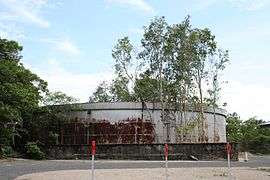 Former World War II fuel installation, now arts centre, 2008 | |||||||||||||||
 Edge Hill | |||||||||||||||
| Coordinates | 16°54′07″S 145°44′35″E / 16.9019°S 145.7430°ECoordinates: 16°54′07″S 145°44′35″E / 16.9019°S 145.7430°E | ||||||||||||||
| Population | 3,916 (2016 census)[1] | ||||||||||||||
| • Density | 1,450/km2 (3,760/sq mi) | ||||||||||||||
| Postcode(s) | 4870 | ||||||||||||||
| Area | 2.7 km2 (1.0 sq mi) | ||||||||||||||
| LGA(s) | Cairns Region | ||||||||||||||
| State electorate(s) | Cairns | ||||||||||||||
| Federal Division(s) | Leichhardt | ||||||||||||||
| |||||||||||||||
Edge Hill is a suburb of Cairns in the Cairns Region, Queensland, Australia.[2]
History
Edge Hill State School opened on 5 February 1940.[3]
Heritage listings
Edge Hill has the following heritage listings:
- Collins Avenue: Flecker Botanical Gardens[4]
- Collins Avenue: WWII RAN Fuel Installation[5]
References
- ↑ Australian Bureau of Statistics (27 June 2017). "Edge Hill (State Suburb)". 2016 Census QuickStats. Retrieved 18 April 2018.

- ↑ "Edge Hill - suburb in Cairns Region (entry 48617)". Queensland Place Names. Queensland Government. Retrieved 30 July 2017.
- ↑ "Opening and closing dates of schools in Queensland". Education Queensland. Retrieved 3 February 2018.
- ↑ "Flecker Botanical Gardens (entry 602541)". Queensland Heritage Register. Queensland Heritage Council. Retrieved 7 July 2013.
- ↑ "WWII RAN Fuel Installation (entry 602605)". Queensland Heritage Register. Queensland Heritage Council. Retrieved 7 July 2013.
External links
| Wikimedia Commons has media related to Edge Hill, Queensland. |
- "Edge Hill". Queensland Places. Centre for the Government of Queensland, University of Queensland.
This article is issued from
Wikipedia.
The text is licensed under Creative Commons - Attribution - Sharealike.
Additional terms may apply for the media files.