The Nation, Ontario
| The Nation La Nation | |
|---|---|
| Municipality (lower-tier) | |
|
The Nation Municipality Municipalité de La Nation | |
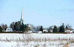 St. Isidore | |
 | |
 The Nation | |
| Coordinates: 45°21′N 75°02′W / 45.350°N 75.033°WCoordinates: 45°21′N 75°02′W / 45.350°N 75.033°W | |
| Country |
|
| Province |
|
| County | Prescott and Russell |
| Incorporated | 1998 |
| Government | |
| • Type | Township |
| • Mayor | François St. Amour |
| • Federal riding | Glengarry—Prescott—Russell |
| • Prov. riding | Glengarry—Prescott—Russell |
| Area[1] | |
| • Total | 658.03 km2 (254.07 sq mi) |
| Population (2016)[1] | |
| • Total | 12,808 |
| • Density | 19.5/km2 (51/sq mi) |
| Time zone | UTC-5 (EST) |
| • Summer (DST) | UTC-4 (EDT) |
| Postal code | K0A, K0B |
| Area code(s) | 613 |
| Website | www.nationmun.ca |
The Nation (La Nation in French) is a municipality in eastern Ontario, located within Canada's National Capital Region, in the United Counties of Prescott and Russell. The municipality consists of the former geographic townships of Caledonia, Cambridge and South Plantagenet.
The municipality is crossed by the South Nation River that connects Larose Forest and Alfred Bog. The Ontario Ministry of Natural Resources has designated the Alfred Bog as "a provincially significant wetland and an Area of Natural and Scientific Interest." Species of interest include the palm warbler, northern pitcher-plant, pink lady's slipper, cottongrass, bog elfin and bog copper butterflies, and ebony boghaunter dragonfly. It also hosts one of the most southerly herds of moose. The bog is open to the public with a 272 metres (892 ft) boardwalk for nature walks.[2] The Prescott and Russell Recreational Trail goes through the township.
Communities
The township comprises the communities of Benoit, Bradley Creek, Caledonia Springs, Fenaghvale, Forest Park, Fournier, Franklins Corners, Gagnon, Johnsons Ferry, Lalonde, Limoges, Longtinville, Martels Corners, Mayerville, Parkers Corners, Proulx, Riceville, Routhier, Sandown, Skye, St. Albert, St. Amour, St. Bernardin, Ste-Rose-de-Prescott, St. Isidore and Velfranc. The township administrative offices are located north of Casselman on Route 500, with a satellite office in Fournier.
The ghost town of Lemieux, abandoned in the early 1990s, is also located within the municipality.
Demographics
| Canada census – The Nation, Ontario community profile | |||
|---|---|---|---|
| 2016 | 2011 | 2006 | |
| Population: | 12,808 (9.8% from 2011) | 11,668 (9.4% from 2006) | 11,078 (0.4% from 2001) |
| Land area: | 658.03 km2 (254.07 sq mi) | 657.16 km2 (253.73 sq mi) | |
| Population density: | 17.7/km2 (46/sq mi) | 16.2/km2 (42/sq mi) | |
| Median age: | 38.1 (M: 38.3, F: 37.7) | ||
| Total private dwellings: | 4,917 | 4432 | 4059 |
| Median household income: | $62,222 | ||
| Notes: Includes corrections and updates – References: 2016[3] 2011[4] 2006[5] earlier[6] | |||
The Nation experienced significant growth between 2006 and 2011. According to the 2011 Statistics Canada census, The Nation's population is 11,668, a 9.4% increase from 10,643 in 2006. There are more than 4,400 dwellings in 658.03 km2 with the average population density per km2 being 17.7.[1]
The Nation also contains one of the larger concentrations of the French in Ontario. According to the 2006 Statistics Canada census, 70% of the population have French as their first language, while 25% have English as their first language.
See also
- Transit Eastern Ontario operated under the authority of The North Glengarry Prescott Russell (NGPR) Transport Board
- List of townships in Ontario
- List of francophone communities in Ontario
References
- 1 2 3 The Nation Census Profile. Statistics Canada. Published 2012-02-08. Accessed 2012-02-08.
- ↑ The Alfred Bog, Ottawa Field-Naturalists' Club
- ↑ "2016 Community Profiles". Canada 2016 Census. Statistics Canada. February 21, 2017.
- ↑ "2011 Community Profiles". Canada 2011 Census. Statistics Canada. July 5, 2013. Retrieved 2012-02-28.
- ↑ "2006 Community Profiles". Canada 2006 Census. Statistics Canada. March 30, 2011. Retrieved 2012-02-28.
- ↑ "2001 Community Profiles". Canada 2001 Census. Statistics Canada. February 17, 2012.
External links
| Wikimedia Commons has media related to The Nation, Ontario. |
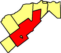
Places adjacent to The Nation, Ontario | |
|---|---|