Martel Inlet
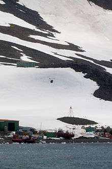 Martel Inlet Lighthouse located at Comandante Ferraz Antarctic Station | |
 Martel Inlet Antarctica | |
| Location |
Martel Inlet Comandante Ferraz Station King George Island Antarctica |
|---|---|
| Coordinates | 62°05′02″S 58°23′31″W / 62.083833°S 58.392083°W |
| Year first constructed | 2007[1] |
| Foundation | concrete base |
| Construction | metal skeletal tower |
| Tower shape | square pyramidal skeletal tower with balcony and light |
| Markings / pattern | red and white tower, red lantern |
| Height | 4 metres (13 ft)[2] |
| Focal height | 14 metres (46 ft)[2] |
| Light source | solar power |
| Range | 10 nautical miles (19 km; 12 mi)[2] |
| Characteristic | Iso R 2s.[2] |
| Admiralty number | G1387.5[2] |
| NGA number | 2729[2] |
| Managing agent | Proantar[1] |
Martel Inlet (62°5′S 58°22′W / 62.083°S 58.367°WCoordinates: 62°5′S 58°22′W / 62.083°S 58.367°W) is an inlet forming the northeast head of Admiralty Bay, King George Island, in the South Shetland Islands off Antarctica. It was charted in December 1909 by the Fourth French Antarctic Expedition under Jean-Baptiste Charcot and named "Fiord Martel" after J.L. Martel, a French politician.[3]
See also
References
- 1 2 "Antarctica". The Lighthouse Directory. University of North Carolina at Chapel Hill. Retrieved 23 May 2017.
- 1 2 3 4 5 6 List of Lights, Pub. 111: The West Coasts of North and South America (Excluding Continental U.S.A. and Hawaii), Australia, Tasmania, New Zealand, and the Islands of the North and South Pacific Oceans (PDF). List of Lights. United States National Geospatial-Intelligence Agency. 2017.
- ↑ "Martel Inlet". Geographic Names Information System. United States Geological Survey. Retrieved 2013-08-16.
![]()
This article is issued from
Wikipedia.
The text is licensed under Creative Commons - Attribution - Sharealike.
Additional terms may apply for the media files.