Marokarima
| Marokarima | |
|---|---|
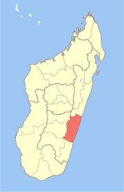
 Marokarima Location in Madagascar | |
| Coordinates: 21°13′S 48°8′E / 21.217°S 48.133°E | |
| Country |
|
| Region | Vatovavy-Fitovinany |
| District | Mananjary |
| Elevation[1] | 25 m (82 ft) |
| Population (2001)[2] | |
| • Total | 14,000 |
| Time zone | UTC3 (EAT) |
Marokarima is a town and commune in Madagascar. It belongs to the district of Mananjary, which is a part of Vatovavy-Fitovinany Region. The population of the commune was estimated to be approximately 14,000 in 2001 commune census.[2]
The majority 99.5% of the population of the commune are farmers. The most important crops are coffee and bananas; also sugarcane is an important agricultural product. Services provide employment for 0.5% of the population.[2]
References and notes
- ↑ Estimated based on DEM data from Shuttle Radar Topography Mission
- 1 2 3 "ILO census data". Cornell University. 2002. Retrieved 2008-05-03.
Coordinates: 21°13′S 48°8′E / 21.217°S 48.133°E
This article is issued from
Wikipedia.
The text is licensed under Creative Commons - Attribution - Sharealike.
Additional terms may apply for the media files.