Marius Hills

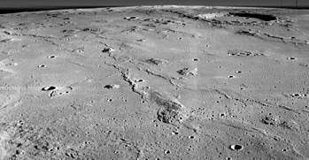

The Marius Hills are a set of volcanic domes located in Oceanus Procellarum on Earth's Moon. The domes are thought to have formed from lavas fairly more viscous than those that formed the Lunar mare. These domes average approximately 200–500 m (660–1,640 ft) in height.[1][2][3] The Marius Hills take their name from the nearby 41 km (25 mi) diameter crater Marius.[4] These hills represent the highest concentration of volcanic features on the Moon.[5]
Geography and geology
An abundance of domes, cones, and volcanic rilles and channels is characteristic of the Marius Hills. The Lunar Reconnaissance Orbiter photographed a pit that could be a skylight in a lava tube, indicating that part of its roof has collapsed, as often happens after lava tubes cease to be active.[3][6]
Data from the Lunar Reconnaissance Orbiter has been used to identify two different varieties of domes among the Marius Hills: (1) large, irregularly shaped domes and (2) smaller domes with steep sides and diameters of about 1–2 km (0.62–1.24 mi). Another feature, possibly pyroclastic, or primarily volcanic in composition, has a roughly circular shape and steep sides. Bright, high albedo boulders have been shown to be characteristic of lava flows in the Marius Hills. This suggests blocky lava with a high silica content formed these features. This hypothesis, however, is not supported by data obtained from the Clementine lunar orbiter. Analysis of lower albedo, or less reflective boulders suggest that many domes in the area may contain two layers of material: (1) an upper layer of thin, dark material covering (2) a layer of thick, bright material.[5]
The Marius Hills region was at one time considered a possible landing site for a lunar landing mission during the American Apollo program (eventually becoming the alternative site for Apollo 15), with the possibility of gaining insight about the volcanic history of the Moon from domes in the area.[7]
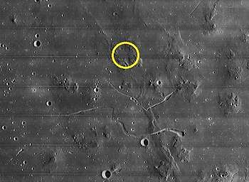
Marius Hills "Hole"
The hole, first discovered by the Japanese SELenological and ENgineering Explorer (SELENE) and then later imaged by the Lunar Reconnaissance Orbiter[8] has been the subject of much research and speculation. There is a possibility that this feature could be a skylight in a lava tube.[9] The depth of this hole is estimated to be between 80 and 88 m (262 and 289 ft) and its width is estimated to be several hundreds of meters.[10]
This tube could provide radiation shielding for a future underground lunar colony. However, it is unclear whether the tube is open or accessible. Two other lunar sites have been found by remote sensing, including on the far side's Mare Ingenii.[11] An even larger, intact but buried lava tube estimated to be 1.7 km in length and 120m wide was detected by the Chandrayaan-1 orbiter.[12]
Apollo program
The Marius Hills region was at one time considered a possible landing site for a lunar landing mission during the American Apollo program (eventually becoming the alternative site for Apollo 15), with the possibility of gaining insight about the volcanic history of the Moon from domes in the area.[7]
A site in the northern Marius Hills, located in the center of a five-kilometer circle in a shallow valley between four domes near a small sinuous depression, was one of nine potential Apollo landing sites studied in-depth as part of a 1968 Bellcom report describing the geology of those nine locations and potential mission plans. This suggested site in particular, the Bellcom study suggested, could have allowed up-close examination of planetary ridges similar to those located at the bottoms of Earth's oceans and sampling of a variety of material from the Moon's interior churned up during the area's highly active volcanic past.[13] The Bellcom study referenced an earlier 1968 study, prepared by the United States Geological Survey, that outlined a detailed mission plan for the proposed site. This plan included four EVAs using a Lunar Roving Vehicle and Lunar Flying Units for increased mobility in sampling the various features in the site radius.[14]
References
- ↑ "Marius Hills". Lunar Reconnaissance Orbiter. National Aeronautics and Space Administration. Retrieved 13 December 2010.
- ↑ "Marius Hills, Moon". Lunar and Planetary Institute. Retrieved 13 December 2010.
- 1 2 Greeley, Ronald (1971). "Lava Tubes and Channels in the Lunar Marius Hills". Earth, Moon, and Planets. 3 (3): 289–314. Bibcode:1971Moon....3..289G. doi:10.1007/BF00561842. Retrieved 13 December 2010.
- ↑ "Oblique view of the Marius Hills and Oceanus Procellarum on the Moon". The Moon - Lunar Orbiter 2. National Aeronautics and Space Administration. Retrieved 13 December 2010.
- 1 2 Lawrence; et al. "LROC Observations of the Marius Hills" (PDF). Retrieved 13 December 2010.
- ↑ "Marius Hills Pit - Lava Tube Skylight?". Lunar Reconnaissance Orbiter Camera. Arizona State University. Retrieved 13 December 2010.
- 1 2 "Lunar Orbiter: Prospective Apollo Landing Sites". Lunar and Planetary Institute. Retrieved 18 June 2011.
- ↑ Clark, Liat (9 February 2011), First underground cave photographed on the moon, Wired UK, archived from the original on 10 February 2011, retrieved 24 January 2016
- ↑ "The Marius Hills hole is a possible skylight". Photojournal. Jet Propulsion Laboratory. Retrieved 28 June 2011.
- ↑ "Marius Hills Flyover". Lunar and Planetary Institute. Retrieved 28 June 2011.
- ↑ Courtland, Rachel (October 22, 2009). "Found: first 'skylight' on the moon". Space. New Scientist. Retrieved 2009-10-25.
- ↑ A. S. Arya, R. P. Rajasekhar, Guneshwar Thangjam, Ajai and A. S. Kiran Kumar, "Detection of potential site for future human habitability on the Moon using Chandrayaan-1 data", Current Science, Vol. 100, NO. 4, 25 February 2011 (accessed 24 January 2015)
- ↑ El-Baz, Farouk. "Geologic Characteristics of the Nine Lunar Landing Mission Sites Recommended by the Group for Lunar Exploration Planning" (PDF). Lunar and Planetary Institute. Retrieved 29 December 2017.
- ↑ Karlstrom, T. N. V.; McCauley, J. F.; Swann, G. A. "Preliminary Lunar Exploration Plan of the Marius Hills Region of the Moon" (PDF). United States Geological Survey. Retrieved 29 December 2017.
External links
| Wikimedia Commons has media related to Marius Hills. |
- Nemiroff, R.; Bonnell, J., eds. (October 25, 2017). "Marius Hills: Holes in the Moon". Astronomy Picture of the Day. NASA.