Marina, San Diego
| Marina, San Diego | |
|---|---|
| Neighborhood of San Diego | |
| Marina | |
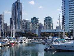 Southeastern part of the Marina district viewed from Marina Park. | |
 Marina, San Diego Location within Central San Diego | |
| Coordinates: 32°42′42″N 117°10′9″W / 32.71167°N 117.16917°W | |
| Country |
|
| State |
|
| County |
|
| City |
|
| Area[1] | |
| • Total | 1.39 km2 (0.536 sq mi) |
| • Land | 1.39 km2 (0.536 sq mi) |
| Population (2008)[1] | |
| • Total | 3,894 |
| • Density | 2,803/km2 (7,261/sq mi) |
| ZIP Code | 92101 |
| Area code(s) | 619 |
The Marina district is a neighborhood in the southwest section of Downtown San Diego, California, U.S.
Geography
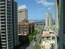
View of west end of Market St., viewed from the 14th floor of Renaissance condominiums, which is located at First and Market.
The district is bordered to the north by the Columbia district, bordered to east/south-east by the Gaslamp Quarter, and is bordered to the south-west by the San Diego Marina.[2]
This district used to be full of warehouses and vacant lots,[3] but now it houses mid-rise and high-rise hotels, apartments, condominiums, medical offices and retail. Seaport Village and the San Diego Convention Center are located in this neighborhood. Pantoja Park, the oldest park in San Diego, is located in the Marina District.
See also
External links
References
- 1 2 Data for the Marina district
- ↑ Neighborhood Map Archived 2007-10-09 at the Wayback Machine.. Centre City Development Corporation. Retrieved on 2007-09-18.
- ↑ "Marina District". San Diego Convention & Visitors Bureau. Retrieved 2007-04-02. External link in
|publisher=(help)
Coordinates: 32°42′42″N 117°10′9″W / 32.71167°N 117.16917°W
This article is issued from
Wikipedia.
The text is licensed under Creative Commons - Attribution - Sharealike.
Additional terms may apply for the media files.