Mapleton, Illinois
| Mapleton | |
|---|---|
| Village | |
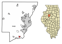 Location of Mapleton in Peoria County, Illinois. | |
.svg.png) Location of Illinois in the United States | |
| Coordinates: 40°34′22″N 89°43′42″W / 40.57278°N 89.72833°WCoordinates: 40°34′22″N 89°43′42″W / 40.57278°N 89.72833°W | |
| Country | United States |
| State | Illinois |
| County | Peoria |
| Area[1] | |
| • Total | 0.93 sq mi (2.42 km2) |
| • Land | 0.93 sq mi (2.42 km2) |
| • Water | 0.00 sq mi (0.00 km2) |
| Population (2010) | |
| • Total | 270 |
| • Estimate (2016)[2] | 279 |
| • Density | 299.04/sq mi (115.41/km2) |
| Time zone | UTC-6 (CST) |
| • Summer (DST) | UTC-5 (CDT) |
| ZIP Code(s) | 61547 |
| Area code(s) | 309 |
| FIPS code | 17-46643 |
| Wikimedia Commons | Mapleton, Illinois |
Mapleton is a small village in Peoria County, Illinois, United States. The population was 227 at the 2000 census. Mapleton is part of the Peoria, Illinois Metropolitan Statistical Area. There are four different plants in Mapleton, all located along U.S. Route 24: an Evonik chemical plant, a Lonza Group plant, a Caterpillar Inc. foundry, and an Ingredion facility; together, the large industrial complex forms one of Mapleton's (and the wider Peoria area's) most significant employers and a good source of skilled employees and good jobs.
Geography
Mapleton is located at 40°34′22″N 89°43′42″W / 40.572758°N 89.728249°W.[3]
According to the 2010 census, Mapleton has a total area of 0.91 square miles (2.36 km2), all land.[4]
Demographics
| Historical population | |||
|---|---|---|---|
| Census | Pop. | %± | |
| 1880 | 135 | — | |
| 1960 | 309 | — | |
| 1970 | 281 | −9.1% | |
| 1980 | 255 | −9.3% | |
| 1990 | 216 | −15.3% | |
| 2000 | 227 | 5.1% | |
| 2010 | 270 | 18.9% | |
| Est. 2016 | 279 | [2] | 3.3% |
| U.S. Decennial Census[5] | |||
As of the census[6] of 2000, there were 227 people, 100 households, and 57 families residing in the village. The population density was 316.1 people per square mile (121.7/km²). There were 111 housing units at an average density of 154.6 per square mile (59.5/km²). The racial makeup of the village was 96.92% White, 1.32% Native American, and 1.76% from two or more races.
There were 100 households out of which 21.0% had children under the age of 18 living with them, 51.0% were married couples living together, 3.0% had a female householder with no husband present, and 43.0% were non-families. 36.0% of all households were made up of individuals and 18.0% had someone living alone who was 65 years of age or older. The average household size was 2.27 and the average family size was 3.07.
In the village, the population was spread out with 16.3% under the age of 18, 11.0% from 18 to 24, 30.0% from 25 to 44, 27.8% from 45 to 64, and 15.0% who were 65 years of age or older. The median age was 41 years. For every 100 females, there were 122.5 males. For every 100 females age 18 and over, there were 118.4 males.
The median income for a household in the village was $45,357, and the median income for a family was $63,750. Males had a median income of $35,208 versus $19,423 for females. The per capita income for the village was $22,728. About 3.3% of families and 6.6% of the population were below the poverty line, including none of those under the age of eighteen or sixty five or over.
References
- ↑ "2016 U.S. Gazetteer Files". United States Census Bureau. Retrieved Jun 29, 2017.
- 1 2 "Population and Housing Unit Estimates". Retrieved June 9, 2017.
- ↑ "US Gazetteer files: 2010, 2000, and 1990". United States Census Bureau. 2011-02-12. Retrieved 2011-04-23.
- ↑ "G001 - Geographic Identifiers - 2010 Census Summary File 1". United States Census Bureau. Retrieved 2015-10-26.
- ↑ "Census of Population and Housing". Census.gov. Retrieved June 4, 2015.
- ↑ "American FactFinder". United States Census Bureau. Retrieved 2008-01-31.
Municipalities and communities of Peoria County, Illinois, United States | ||
|---|---|---|
| Cities | ||
| Villages | ||
| Townships | ||
| CDPs | ||
| Other unincorporated communities |
| |
| Footnotes | ‡This populated place also has portions in an adjacent county or counties | |