Maple Grove, Benzie County, Michigan
| Maple Grove, Michigan | |
|---|---|
| Census-designated place & Unincorporated community | |
 Maple Grove Location within the state of Michigan | |
| Coordinates: 44°42′30″N 85°51′12″W / 44.70833°N 85.85333°WCoordinates: 44°42′30″N 85°51′12″W / 44.70833°N 85.85333°W | |
| Country | United States |
| State | Michigan |
| County | Benzie |
| Township | Almira |
| Area | |
| • Total | 0.3 sq mi (0.9 km2) |
| • Land | 0.3 sq mi (0.9 km2) |
| • Water | 0 sq mi (0 km2) |
| Elevation | 820 ft (250 m) |
| Population (2010) | |
| • Total | 132 |
| • Density | 379/sq mi (146.4/km2) |
| Time zone | UTC-5 (Eastern (EST)) |
| • Summer (DST) | UTC-4 (EDT) |
| FIPS code | 26-50970[1] |
| GNIS feature ID | 2583753[2] |
Maple Grove is an unincorporated community and census-designated place in Benzie County, Michigan, United States. The population was 132 at the 2010 census.[3]
Geography
Maple Grove is located in southeastern Almira Township in northeastern Benzie County. The CDP is located on the south shore of Lake Ann.
According to the United States Census Bureau, the CDP has a total area of 0.35 square miles (0.9 km2), all land.[3]
References
- ↑ "American FactFinder". United States Census Bureau. Retrieved 2008-01-31.
- ↑ U.S. Geological Survey Geographic Names Information System: Maple Grove, Benzie County, Michigan
- 1 2 "Geographic Identifiers: 2010 Demographic Profile Data (G001): Maple Grove CDP, Michigan". U.S. Census Bureau, American Factfinder. Retrieved January 7, 2014.
Municipalities and communities of Benzie County, Michigan, United States | ||
|---|---|---|
| City | 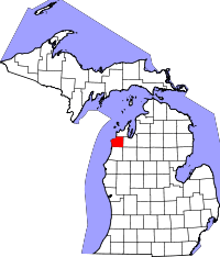 | |
| Villages | ||
| Townships | ||
| CDPs | ||
| Indian reservation | ||
| Footnotes | ‡This populated place also has portions in an adjacent county or counties | |
This article is issued from
Wikipedia.
The text is licensed under Creative Commons - Attribution - Sharealike.
Additional terms may apply for the media files.