Mansalay, Oriental Mindoro
| Mansalay | |
|---|---|
| Municipality | |
| Municipality of Mansalay | |
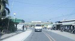 Downtown area | |
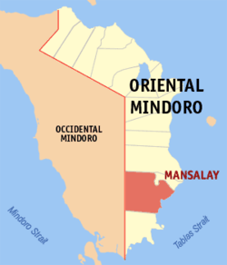 Map of Oriental Mindoro with Mansalay highlighted | |
.svg.png) Mansalay Location within the Philippines | |
| Coordinates: 12°31′N 121°26′E / 12.52°N 121.43°ECoordinates: 12°31′N 121°26′E / 12.52°N 121.43°E | |
| Country |
|
| Region | Mimaropa (Region IV-B) |
| Province | Oriental Mindoro |
| District | 2nd District |
| Barangays | 17 (see Barangays) |
| Government [1] | |
| • Type | Sangguniang Bayan |
| • Mayor | Jose Ildefonso M. Maliwanag |
| • Electorate | 24,134 voters (2016) |
| Area [2] | |
| • Total | 446.62 km2 (172.44 sq mi) |
| Population (2015 census)[3] | |
| • Total | 54,533 |
| • Density | 120/km2 (320/sq mi) |
| Time zone | UTC+8 (PST) |
| ZIP code | 5213 |
| PSGC | 175207000 |
| IDD : area code | +63 (0)43 |
| Climate type | Tropical climate |
| Income class | 2nd municipal income class |
| Revenue (₱) | 154,936,645.66 (2016) |
| Native languages |
Buhid Hanunó'o language Ratagnon Romblomanon Tagalog |
Mansalay, officially the Municipality of Mansalay, is a 2nd class municipality in the province of Oriental Mindoro, Philippines. According to the 2015 census, it has a population of 54,533 people.[3]
This town is notable for its indigenous Mangyan population. The municipal hall is located on the upper land of Mansalay Town proper, in front of a Medical Care Hospital. Nearby is the church and the only Catholic School, Mansalay Catholic High School. Sta. Catalina is the town's patron saint.
The town also has a wide ammonite formation area discovered in the 1940s. Since then, thousands of ammonite fossils have been discovered. Due to the complexity and vastness of the collection found in the area, the town has been called the Ammonite Capital of the Philippines. Various local and international scientific institutions have conducted research on the ammonite formations of Mansalay. Scholars have argued that due to the natural significance of the area to Southeast Asian pre-history, the site has a big chance of being declared as a UNESCO World Heritage Site or a UNESCO Geopark Reserve.[4][5] It is 144 kilometres (89 mi) from Calapan.
Barangays
Mansalay is politically subdivided into 17 barangays.
| Barangay | Population (2016) |
|---|---|
| B. Del Mundo | 8,208 |
| Balugo | 2,663 |
| Bonbon | 1,955 |
| Budburan | 1,370 |
| Cabalwa | 1,192 |
| Don Pedro | 3,077 |
| Maliwanag | 1,731 |
| Manaul | 3,321 |
| Panaytayan | 10,592 |
| Poblacion | 4,201 |
| Roma | 1,993 |
| Santa Brigida | 2,083 |
| Santa Maria | 1,980 |
| Villa Celestial | 1,649 |
| Wasig | 2,323 |
| Santa Teresita | 4,711 |
| Waygan | 1,484 |
| Total | 54,533 |
History
In 1957, the sitios of Sta. Brigida, Sta. Maria, Roma, Budburan, and Mahabangsapa were constituted into barrios.[6]
Demographics
| Population census of Mansalay | ||
|---|---|---|
| Year | Pop. | ±% p.a. |
| 1939 | 7,003 | — |
| 1948 | 11,223 | +5.38% |
| 1960 | 14,669 | +2.26% |
| 1970 | 18,395 | +2.29% |
| 1975 | 19,544 | +1.22% |
| 1980 | 23,548 | +3.80% |
| 1990 | 27,515 | +1.57% |
| 1995 | 29,765 | +1.48% |
| 2000 | 39,041 | +5.99% |
| 2007 | 43,974 | +1.65% |
| 2010 | 51,705 | +6.07% |
| 2015 | 54,533 | +1.02% |
| Source: Philippine Statistics Authority[3][7][8][9] | ||
Economy
Its people relies heavily on fishing and farming to survive and earn a living. Because of meager income opportunities, Mansalay has produced a large number of overseas Filipino workers who send remittance back.
References
- ↑ "Municipality". Quezon City, Philippines: Department of the Interior and Local Government. Retrieved 31 May 2013.
- ↑ "Province: Oriental Mindoro". PSGC Interactive. Quezon City, Philippines: Philippine Statistics Authority. Retrieved 12 November 2016.
- 1 2 3 Census of Population (2015). "Region IV-B (Mimaropa)". Total Population by Province, City, Municipality and Barangay. PSA. Retrieved 20 June 2016.
- ↑ https://www.kahaku.go.jp/english/research/researcher/papers/123551.pdf
- ↑ http://newsinfo.inquirer.net/679848/mindoro-students-discover-jurassic-town
- ↑ "An Act Creating Certain Barrios in the Municipality of Mansalay, Province of Oriental Mindoro". LawPH.com. Retrieved 2011-04-12.
- ↑ Census of Population and Housing (2010). "Region IV-B (Mimaropa)". Total Population by Province, City, Municipality and Barangay. NSO. Retrieved 29 June 2016.
- ↑ Censuses of Population (1903–2007). "Region IV-B (Mimaropa)". Table 1. Population Enumerated in Various Censuses by Province/Highly Urbanized City: 1903 to 2007. NSO.
- ↑ "Province of Oriental Mindoro". Municipality Population Data. Local Water Utilities Administration Research Division. Retrieved 17 December 2016.
External links
- Philippine Standard Geographic Code
- Philippine Census Information
- Local Governance Performance Management System
- Mansalay Official Home Page
Places adjacent to Mansalay, Oriental Mindoro | |
|---|---|