Manistee Lake, Michigan
| Manistee Lake, Michigan | |
|---|---|
| Unincorporated community | |
 Manistee Lake, Michigan  Manistee Lake, Michigan | |
| Coordinates: 44°47′03″N 85°01′16″W / 44.78417°N 85.02111°WCoordinates: 44°47′03″N 85°01′16″W / 44.78417°N 85.02111°W | |
| Country | United States |
| State | Michigan |
| County | Kalkaska |
| Area[1] | |
| • Total | 4.935 sq mi (12.78 km2) |
| • Land | 3.557 sq mi (9.21 km2) |
| • Water | 1.378 sq mi (3.57 km2) |
| Elevation | 1,194 ft (364 m) |
| Population (2010)[1] | |
| • Total | 456 |
| • Density | 92/sq mi (36/km2) |
| Time zone | UTC-5 (Eastern (EST)) |
| • Summer (DST) | UTC-4 (EDT) |
| Area code(s) | 231 |
| GNIS feature ID | 2583751[2] |
Manistee Lake is an unincorporated community and census-designated place in Kalkaska County, Michigan, United States. Its population was 456 as of the 2010 census.[1]
Geography
According to the U.S. Census Bureau, the community has an area of 4.935 square miles (12.78 km2); 3.557 square miles (9.21 km2) of its area is land, and 1.378 square miles (3.57 km2) is water.[1]
References
Municipalities and communities of Kalkaska County, Michigan, United States | ||
|---|---|---|
| Village | 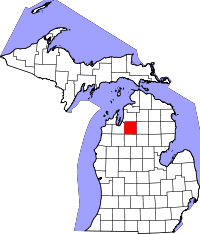 | |
| Townships | ||
| CDPs | ||
This article is issued from
Wikipedia.
The text is licensed under Creative Commons - Attribution - Sharealike.
Additional terms may apply for the media files.