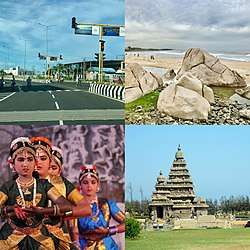
Mamallapuram
| Mamallapuram Mamallapuram | |
|---|---|
| town | |
 The town of Mamallapuram (Mamallapuram) | |
 Mamallapuram | |
| Coordinates: 12°36′59″N 80°11′58″E / 12.616454°N 80.199370°ECoordinates: 12°36′59″N 80°11′58″E / 12.616454°N 80.199370°E | |
| Country | India |
| State | Tamil Nadu |
| District | Kancheepuram |
| Elevation | 12 m (39 ft) |
| Population (2011) | |
| • Total | 15,172[1] |
| Languages | |
| • Official | Tamil |
| Time zone | UTC+5:30 (IST) |
| PIN | 603104 |
| Telephone code | 91-44 |
| Website | https://tourismtn.com/mahabalipuram |
Mamallapuram or Seven Pagodas or Mahabalipuram, is a town in Kancheepuram district in the southeastern Indian state of Tamil Nadu.[1] It is on the coastline 58 kilometres (36 mi) south of the city of Chennai. An ancient historic town and a bustling seaport in the 1st millennium CE, now a beachside tourism center with a group of Tamil monuments declared as UNESCO world heritage site, it is one of the most visited towns in South India.[1][2]
Mamallapuram was one of two major port cities by the 7th century within the Pallava kingdom. Along with economic prosperity, it became a center of a group of battle monuments carved out of rock. These are dated to the 7th and 8th centuries: rathas (temples in the form of chariots), mandapas (cave sanctuaries), giant open-air rock reliefs such as the famous Descent of the Ganges, and the Shore Temple dedicated to Shiva, Durga, Vishnu, Krishna and others.[1][2] The contemporary town plan was established by the British Raj in 1827.[3]
History
Neolithic burial urn, cairn circles and jars with burials dating to the very dawn of the Christian era have been discovered near Mamallapuram. The Sangam age poem Perumpāṇāṟṟuppaṭai relates the rule of King Thondaiman Ilam Thiraiyar at Kanchipuram of the Tondai Nadu port Nirppeyyaru which scholars identify with the present-day Mamallapuram. Chinese coins and Roman coins of Theodosius I in the 4th century CE have been found at Mamallapuram revealing the port as an active hub of global trade in the late classical period. Two Pallava coins bearing legends read as Srihari and Srinidhi have been found at Mamallapuram. The Pallava kings ruled Mamallapuram from Kanchipuram; the capital of the Pallava dynasty from the 3rd century to 9th century CE, and used the port to launch trade and diplomatic missions to Sri Lanka and Southeast Asia.
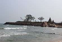
An 8th-century Tamil text written by Thirumangai Alvar described this place as Sea Mountain ‘where the ships rode at anchor bent to the point of breaking laden as they were with wealth, big trunked elephants and gems of nine varieties in heaps’. It is also known by several other names such as MAMALLAPATINAM and Mamallapuram. Another name by which Mamallapuram has been known to mariners, at least since Marco Polo’s time is "Seven Pagodas" alluding to the Seven Pagodas of Mamallapuram that stood on the shore, of which one, the Shore Temple, survives.[4]
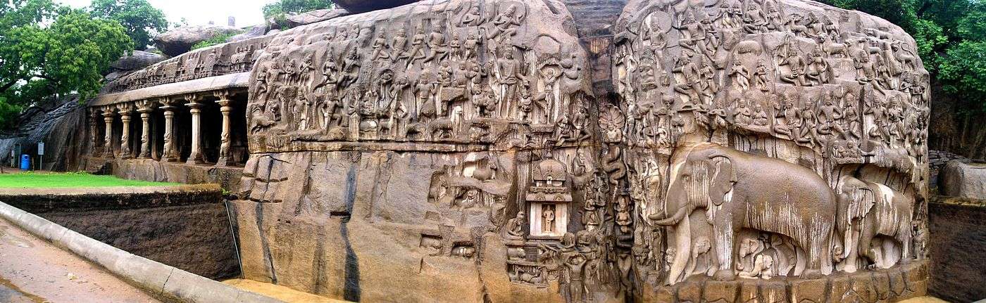
The temples of Mapuram, portraying events described in the Mahabharata, were built largely during the reigns of Narasimhavarman and his successor Rajasimhavarman and show the movement from rock-cut architecture to structural building. The city of Mamallapuram was founded by the Pallava king Narasimhavarman I in the 7th century AD.[4] The mandapa or pavilions and the rathas or shrines shaped as temple chariots are hewn from the granite rock face, while the famed Shore Temple, erected half a century later, is built from dressed stone. What makes Mamallapuram so culturally resonant are the influences it absorbs and disseminates. The Shore Temple includes many reliefs, including one 100 ft. long and 45 ft. high, carved out of granite.[5]
Transport
MTC and TNSTC (Villupuram) Kanchipuram division buses are operating bus from Chennai, Chengalpattu, Kancheepuram, Thiruttani etc. Apart from TNSTC MTC operating buses to Mahabalipuram from various parts of the city with Deluxe and Air conditioned Deluxe buses
MTC bus Routes towards Mahabalipuram
| Route Number | Start | End | Via |
|---|---|---|---|
| 515 | Tambaram | Mamallapuram/Mahabalipuram | Vandalore Zoo, Kelambakkam, Thirupporur |
| 568 | Adyar | Mamallapuram/Mahabalipuram | Perugudi, Sholinganallur, Kelambakkam, Thirupporur |
| 568C | Koyambedu | Mahabalipuram | Vadapalani, Ashok nagar, Guindy, Madhya kailash, Perugudi, Sholinganallur, Kelambakkam, Thirupporur |
| 588 | Adyar | Mamallapuram/Mahabalipuram | Thiruvanmiyur, VGP, MGM, Kovalam, Thiruvedanthai, Vadanemmeli, Devanery |
| 588B | Broadway | Mamallapuram/Mahabalipuram | Annasquare, AIR, Santhome, AMS, Adyar, Thiruvanmiyur, VGP, MGM, Kovalam, Thiruvedanthai, Vadanemmeli, Devanery
THIS ROUTE IS AVAILABLE ONLY ON SUNDAY AND GOVERNMENT HOLIDAYS |
| 588C | Koyambedu | Mamallapuram/Mahabalipuram | Vadapalani, Ashok nagar, Guindy, Madhya kailash, Thiruvanmiyur, VGP, MGM, Kovalam, Thiruvedanthai, Vadanemmeli, Devanery |
| 589 | Velachery | Mamallapuram/Mahabalipuram | SRP Tools, Thiruvanmiyur, VGP, MGM, Kovalam, Thiruvedanthai, Vadanemmeli, Devanery |
| 599 | Mamallapuram/Mahabalipuram | T Nagar | Saidapet, Adyar, Thiruvanmiyur, VGP, MGM, Kovalam, Thiruvedanthai, Vadanemmeli, Devanery |
Climate
Mahabalipuram has a tropical climate. The Köppen-Geiger climate classification is Aw. The average annual temperature is 28.4 °C. The temperatures are highest on average in May, at around 32.6 °C. In January, the average temperature is 24.3 °C, the lowest of the year. The average temperatures vary during the year by 8.3 °C. In a year, the average rainfall is 1219 mm. In winter, there is much less rainfall than in summer. The variation in the precipitation between the driest and wettest months is 309 mm.
| Climate data for Mahabalipuram | |||||||||||||
|---|---|---|---|---|---|---|---|---|---|---|---|---|---|
| Month | Jan | Feb | Mar | Apr | May | Jun | Jul | Aug | Sep | Oct | Nov | Dec | Year |
| Average high °C (°F) | 28.9 (84) |
30.4 (86.7) |
32.1 (89.8) |
34.4 (93.9) |
37.6 (99.7) |
37.4 (99.3) |
35.5 (95.9) |
34.9 (94.8) |
34.3 (93.7) |
32.0 (89.6) |
29.3 (84.7) |
28.5 (83.3) |
32.9 (91.3) |
| Daily mean °C (°F) | 24.3 (75.7) |
25.4 (77.7) |
27.2 (81) |
30.0 (86) |
32.6 (90.7) |
32.2 (90) |
30.8 (87.4) |
30.2 (86.4) |
29.7 (85.5) |
28.0 (82.4) |
25.8 (78.4) |
24.6 (76.3) |
28.4 (83.1) |
| Average low °C (°F) | 19.8 (67.6) |
20.4 (68.7) |
22.4 (72.3) |
25.6 (78.1) |
27.6 (81.7) |
27.1 (80.8) |
26.2 (79.2) |
25.5 (77.9) |
25.1 (77.2) |
24.1 (75.4) |
22.4 (72.3) |
20.8 (69.4) |
23.9 (75.1) |
| Average precipitation mm (inches) | 20 (0.79) |
6 (0.24) |
4 (0.16) |
11 (0.43) |
55 (2.17) |
62 (2.44) |
92 (3.62) |
124 (4.88) |
114 (4.49) |
240 (9.45) |
313 (12.32) |
178 (7.01) |
1,219 (48) |
| Average precipitation days | 2 | 1 | 1 | 2 | 3 | 4 | 6 | 8 | 8 | 13 | 15 | 10 | 71 |
| Source: Climate-data.org[6] | |||||||||||||
Landmarks
The town has a collection of 7th and 8th century religious monuments that has been declared as a UNESCO World Heritage site.[1][2][7] It is on the Coromandel Coast of the Bay of Bengal, about 60 kilometres (37 mi) south of Chennai, Tamil Nadu, India.[1]
The site has 40 ancient monuments and Hindu temples,[8] including Descent of the Ganges or Arjuna's Penance – one of the largest open-air rock relief in the world.[1][9] The site includes several categories of monuments: ratha temples with an architecture of monolith processional chariots built between 630 and 668 CE; the mandapa viharas with halls and stone roofs with narratives from the Mahabharata, Shaktism and Vaishnavism; rock reliefs particularly bas-reliefs of Shaivism, Shaktism and Vaishnavism; stone cut temples particularly those dedicated to Shiva that also reverentially display Vishnu and others, built between 695 and 722 CE; and, archaeological excavations with inscriptions some dated to 6th century and earlier.[7][10] The cave temples and monolithic temples were built during the Pallava Period.[2][7][11] The site is managed by the Archaeological Survey of India.[12]
Some important structures include:
- Thirukadalmallai, the temple dedicated to Lord Vishnu. It was also built by Pallava King in order to safeguard the sculptures from the ocean.
- Descent of the Ganges or Arjuna's Penance – a giant open-air rock relief
- Varaha Cave Temple – a small rock-cut temple dating back to the 7th century.
- The Shore Temple – a structural temple along the Bay of Bengal with the entrance from the western side away from the sea. Recent excavations have revealed new structures here.
- Pancha Rathas (Five Chariots) – five monolithic pyramidal structures named after the Pandavas (Arjuna, Bhima, Yudhishtra, Nakula and Sahadeva) and Draupadi. An interesting aspect of the rathas is that, despite their sizes they are not assembled – each of these is carved from one single large piece of stone.
- Light House, built in 1894.
Demography
As of 2001 India census,[13] Mahabalipuram had a population of 12,345.[14] Males constitute 52% of the population and females 48%. Mahabalipuram has an average literacy rate of 74%, higher than the national average of 59.5%: male literacy is 82%, and female literacy is 66%. In Mahabalipuram, 12% of the population is under 6 years of age.
See also
Literature
- Lukas Hartmann: Mahabalipuram oder Als Schweizer in Indien. Ein Reisetagebuch. Arche, Zürich, ISBN 978-3-716-01764-7.
References
- 1 2 3 4 5 6 7 Mamallapuram, Encyclopedia Britannica
- 1 2 3 4 James G. Lochtefeld (2002). The Illustrated Encyclopedia of Hinduism: A-M. The Rosen Publishing Group. p. 399. ISBN 978-0-8239-3179-8.
- ↑ Encyclopedia Britannica, 15th Edition (1982), Vol. VI, p. 497
- 1 2 Sundaresh, A. S. Gaur, Sila Tripati, K. H. Vora (10 May 2004). "Underwater investigations off Mamallapuram" (PDF). Current Science. 86 (9). Archived from the original (PDF) on 5 November 2004.
- ↑ Ancient Discoveries: Lost Cities of the Deep History Channel
- ↑ "Climate: Mahabalipuram". climate-data.org.
- 1 2 3 "Group of Monuments at Mahabalipuram". UNESCO.org. Retrieved 23 October 2012.
- ↑ National Geographic (2008). Sacred Places of a Lifetime: 500 of the World's Most Peaceful and Powerful Destinations. National Geographic Society. p. 154. ISBN 978-1-4262-0336-7.
- ↑ George Michell (1977). The Hindu Temple: An Introduction to Its Meaning and Forms. University of Chicago Press. pp. 131–134. ISBN 978-0-226-53230-1.
- ↑ Group of Monuments at Mahabalipuram, Dist. Kanchipuram, Archaeological Survey of India (2014)
- ↑ "Advisory body evaluation" (PDF). UNESCO.org. Retrieved 23 October 2012.
- ↑ World Heritage Sites - Mahabalipuram, Archaeological Survey of India (2014)
- ↑ "Census of India 2001: Data from the 2001 Census, including cities, villages and towns (Provisional)". Census Commission of India. Archived from the original on 2004-06-16. Retrieved 2008-11-01.
- ↑ "Census of towns in Tamil Nadu" (PDF). Census of India. Retrieved 2012-06-10.
- Sources
- Ayyar, P. V. Jagadisa (1991), South Indian shrines: illustrated, New Delhi: Asian Educational Services, ISBN 81-206-0151-3 .
- The Story of Ancient Sculptures in Mahabalipuram
- Bradnock, Roma; Bradnock, Robert (2009), Footprint India, USA: Patrick Dawson, ISBN 1-904777-00-7 .
- Pippa de Bruyn, Keith Bain, David Allardice (2010). Frommer's India. Frommer's. p. 350. ISBN 978-0-470-55610-8.
- Hurd, James (2010), Temples of Tamilnad, USA: Xilbris Corporation, ISBN 978-1-4134-3843-7 .
- Singh, Sarina (2009), South India (Lonely Planet Regional Guide) (5th ed.), Lonely Planet, ISBN 978-1-74179-155-6
External links
| Wikimedia Commons has media related to Mamallapuram. |
- Mahabalipuram Tourism in just 5 minutes
- The Ancient Sculptures of Mahabalipuram

- Things to do in Mahabalipuram
- Mahabalipuram
- Article on Mahabalipuram
- Mahabalipuram must watch