Malibamat'so River
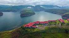
Malibamat'so River in Lesotho.

Course of the Malibamat'so River in northern Lesotho. Map data from Open Street Maps.
The Malibamat'so River is a river in northern Lesotho. It flows south from near to the South African border, past the village of Lejone, and joins the Senqu River 5 kilometres (3.1 mi) northeast of Mohlanapeng.
The Malibamat'so forms the northern arm of the Katse Dam reservoir, a part of the Lesotho Highlands Water Project. Katse is Africa's highest elevation dam at 1,993 metres (6,539 ft) above sea level.[1]
Location
| Point | Coordinates (links to map & photo sources) |
Notes |
|---|---|---|
| Source | 28°42′11″S 28°44′13″E / 28.70299°S 28.73707°E | |
| Katse Dam | 29°20′13″S 28°30′24″E / 29.33703°S 28.50665°E | |
| Senqu River confluence | 29°33′11″S 28°42′23″E / 29.55315°S 28.70649°E |
References
- ↑ Fitzpatrick, M., Blond, B., Pitcher, G., Richmond, S., and Warren, M. (2004) South Africa, Lesotho and Swaziland. Footscray, VIC: Lonely Planet.
This article is issued from
Wikipedia.
The text is licensed under Creative Commons - Attribution - Sharealike.
Additional terms may apply for the media files.