Malagarasi River
| Malagarasi River | |
|---|---|
 | |
| Country | Burundi, Tanzania |
| Physical characteristics | |
| River mouth | 5°15′23″S 29°48′6″E / 5.25639°S 29.80167°ECoordinates: 5°15′23″S 29°48′6″E / 5.25639°S 29.80167°E |
| Length | 475 km (295 mi) |
| Basin features | |
| River system | Congo River |
| Basin size | 130,000 km2 (50,000 sq mi) |
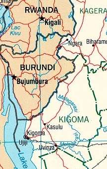
The Malagarasi River is a river of southeastern Burundi and northwestern Tanzania, flowing through Kigoma Region. It is the second-longest river in the country, and has the largest watershed of all of the rivers flowing into Lake Tanganyika.[1] The Malagarasi-Muyovozi Wetlands are a designated a Ramsar site. Local tribes have nicknamed the Malagarasi as "the river of bad spirits".
Geography
The Malagarasi is the second longest river in the country, at 475 kilometres (295 mi),[2][3] and with a basin area of 130,000 square kilometres (50,000 sq mi), the Malagarasi has the largest watershed of all of the rivers flowing into Lake Tanganyika.[1] The source of the river is near the Burundi-Tanzania border.[1] The first 80 kilometres (50 mi) of the river form the international boundary between Tanzania and Burundi. Several tributaries from the Burundi highlands join its right bank. After the confluence with the Lumpungu River, the Malagarasi enters Tanzania, makes a circle and empties into the eastern side of Lake Tanganyika about 25 miles (40 km) south of Kigoma, near Ilagala.[4] It is one of the lake's primary inflows. Moyowosi River is the principal tributary, along with its affluent the Nikongo River;[5] other tributaries include Ugalla River, Gombe River, Ruchugi River, Lumpungu River,[6] and Nguya River. At a length of 475 kilometres (295 mi), it is the second longest river in Tanzania, and with a basin area of 130,000 square kilometres (50,000 sq mi), the Malagasi has the largest watershed of all of the rivers flowing into Lake Tanganyika.[1] Characterized as a low stream river,[7] its drainage includes four biotopes: swampy areas, river channels, a flowing river with a few moderate rapids, and a large double-branched delta.[8]
The flow of the river ranges dramatically between the annual cycle of wet and dry seasons, and at times may be susceptible to flooding or reduced to a small stream; flow is also affected by local agriculture and deforestation which increase the level of sediments within the river.[1] At Mberagule, the flow of the river has been gauged to be 6.9 cubic kilometers.[1] About 80 kilometres (50 mi) from the mouth, the river flows through the Moyowosi swamplands, an area of "extensive swamps and floodplains" and a "marshy labyrinth".[9][10] It passes through the Dodoma Belt, a geological area of Archaean and Proterozoic age Precambrian crystalline rocks.[1]
History
According to Rosemary Lowe-McConnell, "the Malagarasi and the Rungwa River are assumed to be relict headwaters of the extended pre-rift Zaire system".[11] The Malagarasi pre-dates Lake Tanganyika and was in pre-rift times a tributary of the Congo River to its west. Lake Tanganyika has since said to have "undergone both transgression and regression, depositing new sediments, altering the delta, and changing the course of the river".[1] Over its history, the lake level has altered dramatically between 100 and 200 metres; historical accounts from the late nineteenth century indicate that it was about 10 metres (33 ft) higher than it is today.[1]
Culture
Local tribes have nicknamed the Malagarasi as "the river of bad spirits".[12] In the late 19th century, the Wavinza people, who ran the river's ferry service from the left bank, avoided assimilation with the Wanyamwezi people because of the natural barrier formed by the Malagarasi.[13] Also on the other bank were the Wangoni (Watutu Zulus).[14] Henry Morton Stanley, who considered missionaries important to Africa's "civilizing process", stated that missionaries could follow the Malagarasi and participate in "conversion-tours to Uvinza, Uha, and Ugala".[15]
Flora and fauna
The flora includes Albizzia gummifera, Bridelia micrantha, Cyperus papyrus, Diospyros mespiliformis, Ficus sycomorus, Ficus verruculosa, Isoberlinia spp., Khaya senegalensis, Parkia filicoidea, Phoenix reclinata, Syzgium cordatum, and Syzgium owariense.[5] Mesobola spinifer, also known as "Malagarasi Sardine", is endemic to the river.[16] In the valley grasslands there are prominent species such as Hyparrhenia, Themeda, Echinochloa.[17] The Malagarasi contains several fish species which occur in the Congo River Basin but not in Lake Tanganyika.[5] Giant freshwater Mbu pufferfish, however, occur in both the Central and Upper Zaire Basin and the Malagarasi River.[18] Waterbuck and hippopotamus are common in the swamps.[17] Concerns have been raised over hippo poaching in the river basin by the Wanyahosa people, who prefer the meat over fish.[19]
Environmental protection
The Malagarasi-Muyovozi Wetlands became a designated a Ramsar site on April 13, 2000.[20] It is the country's first Ramsar Site. Measuring 35,000 square kilometres (14,000 sq mi), it is the world's third largest Ramsar Site, and contains more than 50 indigenous fish species, such as the Dark stonebasher, being a rare fish species example.[21] The Wetlands are an important part of the Malagarasi River basin, itself constituting about one third of the Lake Tanganyika catchment area.[21]
References
- 1 2 3 4 5 6 7 8 9 Shick, Kate and Flaccus, Kathy. "Malagarasi River Delta Sedimentology: Evidence of Lake Level Changes in Lake Tanganyika" (PDF). Geology Department of the University of Arizona. Retrieved 30 May 2012.
- ↑ Kisangani, Emizet F.; Bobb, F. Scott (2010). Historical Dictionary of the Democratic Republic of the Congo. Scarecrow Press. p. 299. ISBN 978-0-8108-5761-2. Retrieved 30 May 2012.
- ↑ Elf-Aquitaine (Company) (1992). Bulletin des centres de recherches exploration-production Elf-Aquitaine. Société nationale Elf-Aquitaine (Production). Retrieved 30 May 2012.
- ↑ Maps (Map). Google Maps.
- 1 2 3 Hughes, R. H.; Hughes, J. S. (1992). A Directory of African Wetlands. IUCN. pp. 244–. ISBN 978-2-88032-949-5. Retrieved 28 May 2012.
- ↑ Brownlie, Ian; Burns, Ian R. (1979). African Boundaries: A Legal and Diplomatic Encyclopaedia. C. Hurst. p. 748. ISBN 978-0-903983-87-7. Retrieved 30 May 2012.
- ↑ Klerkx, J.; Imanackunov, Beishen (1 January 2003). Lake Issyk-Kul: Its Natural Environment. Springer. pp. 231–. ISBN 978-1-4020-0900-6. Retrieved 28 May 2012.
- ↑ Thieme, Michele L. (5 April 2005). Freshwater Ecoregions of Africa and Madagascar: A Conservation Assessment. Island Press. pp. 197–. ISBN 978-1-55963-365-9. Retrieved 28 May 2012.
- ↑ Kamukala, G. L.; Crafter, S. A. (1993). Wetlands of Tanzania: Proceedings of a Seminar on the Wetlands of Tanzania, Morogoro, Tanzania, 27-29 November, 1991. IUCN Wetlands Programme. p. 34. ISBN 978-2-8317-0185-1. Retrieved 30 May 2012.
- ↑ Lambrecht, Frank L. (1991). In the Shade of an Acacia Tree: Memoirs of a Health Officer in Africa, 1945-1959. American Philosophical Society. p. 217. ISBN 978-0-87169-194-1. Retrieved 30 May 2012.
- ↑ Lévêque, C. (13 May 1997). Biodiversity Dynamics and Conservation: The Freshwater Fish of Tropical Africa. Cambridge University Press. pp. 107–. ISBN 978-0-521-57033-6. Retrieved 28 May 2012.
- ↑ Grant, Richard (25 October 2011). Crazy River: Exploration and Folly in East Africa. Simon and Schuster. pp. 339–. ISBN 978-1-4391-5414-4. Retrieved 4 June 2012.
- ↑ The Journal of the Anthropological Institute of Great Britain and Ireland (Public domain ed.). Anthropological Institute of Great Britain and Ireland. 1883. pp. 8–. Retrieved 4 June 2012.
- ↑ Newman, James L. (2010). Paths Without Glory: Richard Francis Burton in Africa. Potomac Books, Inc. pp. 105–. ISBN 978-1-59797-287-1. Retrieved 4 June 2012.
- ↑ Newman, James L. (1 November 2004). Imperial Footprints: Henry Morton Stanley's African Journeys. Potomac Books, Inc. pp. 81–. ISBN 978-1-57488-597-2. Retrieved 4 June 2012.
- ↑ Seegers, L. (November 15, 2011). "Mesobola spinifer (Bailey & Matthes, 1971) Malagarasi sardine". FishBase. Retrieved 29 May 2012.
- 1 2 Tanzania Society (1980). Tanzania notes and records. Tanzania Society. pp. 96–100. Retrieved 30 May 2012.
- ↑ Davies, Bryan Robert (31 July 1986). The Ecology of River Systems. Springer. p. 218. ISBN 978-90-6193-540-7. Retrieved 30 May 2012.
- ↑ Tanganyika Society (1963). Tanganyika notes and records. Tanganyika Society. p. 210. Retrieved 30 May 2012.
- ↑ "TANZANIA, UNITED REPUBLIC OF Ramsar Site 1024;(WI Site 1TZ001)". Wetlands International. Retrieved 2 June 2012.
- 1 2 "The Project for Sustainable and Integrated Management of the Malagarasi-Muyovozi Ramsar Site (SIMMORS)". Ramsar. March 2007. Retrieved 2 June 2012.