Malaga, New Mexico
| Malaga, New Mexico | |
|---|---|
| Census-designated place | |
 Malaga | |
| Coordinates: 32°13′26″N 104°04′21″W / 32.22389°N 104.07250°WCoordinates: 32°13′26″N 104°04′21″W / 32.22389°N 104.07250°W | |
| Country | United States |
| State | New Mexico |
| County | Eddy |
| Area[1] | |
| • Total | 2.972 sq mi (7.70 km2) |
| • Land | 2.971 sq mi (7.69 km2) |
| • Water | 0.001 sq mi (0.003 km2) |
| Elevation | 3,005 ft (916 m) |
| Population (2010)[2] | |
| • Total | 147 |
| • Density | 49/sq mi (19/km2) |
| Time zone | UTC-7 (Mountain (MST)) |
| • Summer (DST) | UTC-6 (MDT) |
| ZIP code | 88263 |
| Area code(s) | 575 |
| GNIS feature ID | 891551[3] |
Malaga is a census-designated place and unincorporated community in Eddy County, New Mexico, United States. Its population was 147 as of the 2010 census. Malaga has a post office with ZIP code 88263.[4][5] U.S. Route 285 passes through the community.
References
- ↑ "US Gazetteer files: 2010, 2000, and 1990". United States Census Bureau. 2011-02-12. Retrieved 2011-04-23.
- ↑ "American FactFinder". United States Census Bureau. Retrieved 2011-05-14.
- ↑ "Malaga". Geographic Names Information System. United States Geological Survey.
- ↑ United States Postal Service (2012). "USPS - Look Up a ZIP Code". Retrieved 2012-02-15.
- ↑ "Postmaster Finder - Post Offices by ZIP Code". United States Postal Service. Retrieved March 4, 2014.
Municipalities and communities of Eddy County, New Mexico, United States | ||
|---|---|---|
| Cities | 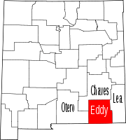 | |
| Villages | ||
| CDPs | ||
| Unincorporated communities | ||
This article is issued from
Wikipedia.
The text is licensed under Creative Commons - Attribution - Sharealike.
Additional terms may apply for the media files.