Atoka, New Mexico
| Atoka, New Mexico | |
|---|---|
| Census-designated place | |
 Atoka | |
| Coordinates: 32°46′10″N 104°23′20″W / 32.76944°N 104.38889°WCoordinates: 32°46′10″N 104°23′20″W / 32.76944°N 104.38889°W | |
| Country | United States |
| State | New Mexico |
| County | Eddy |
| Area[1] | |
| • Total | 6.791 sq mi (17.59 km2) |
| • Land | 6.759 sq mi (17.51 km2) |
| • Water | 0.032 sq mi (0.08 km2) |
| Elevation | 3,376 ft (1,029 m) |
| Population (2010)[2] | |
| • Total | 1,077 |
| • Density | 160/sq mi (61/km2) |
| Time zone | UTC-7 (Mountain (MST)) |
| • Summer (DST) | UTC-6 (MDT) |
| Area code(s) | 575 |
| GNIS feature ID | 898718[3] |
Atoka is a census-designated place in Eddy County, New Mexico, United States. Its population was 1,077 as of the 2010 census.[2] U.S. Route 285 passes through the community.
References
- ↑ "US Gazetteer files: 2010, 2000, and 1990". United States Census Bureau. 2011-02-12. Retrieved 2011-04-23.
- 1 2 "American FactFinder". United States Census Bureau. Archived from the original on 2013-09-11. Retrieved 2011-05-14.
- ↑ "Atoka". Geographic Names Information System. United States Geological Survey.
Municipalities and communities of Eddy County, New Mexico, United States | ||
|---|---|---|
| Cities | 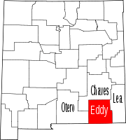 | |
| Villages | ||
| CDPs | ||
| Unincorporated communities | ||
This article is issued from
Wikipedia.
The text is licensed under Creative Commons - Attribution - Sharealike.
Additional terms may apply for the media files.