Malá Hraštice
| Malá Hraštice | |
|---|---|
| Municipality and village | |
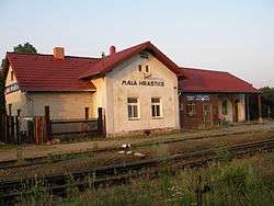 Railway station in Malá Hraštice | |
 Malá Hraštice Location in the Czech Republic | |
| Coordinates: 49°48′27″N 14°16′48″E / 49.8075°N 14.27987°E[1]Coordinates: 49°48′27″N 14°16′48″E / 49.8075°N 14.27987°E[1] | |
| Country |
|
| Region | Central Bohemian Region |
| District | Příbram District |
| Government | |
| • Mayor | Helena Wiedermannová |
| Area[2] | |
| • Total | 928.0513 ha (2,293.2647 acres) |
| Elevation[1] | 357 m (1,171 ft) |
| Population (2018)[3] | |
| • Total | 1,025 |
| • Density | 110/km2 (290/sq mi) |
| Time zone | UTC+01:00 (CET) |
| • Summer (DST) | UTC+02:00 (CEST) |
| ZIP code[4] | 262 04 |
Malá Hraštice is a village and municipality in Příbram District in the Central Bohemian Region of the Czech Republic.
References
- This article was initially translated from the Czech Wikipedia.
- 1 2 3 "GeoNames.org". www.geonames.org. Retrieved 16 September 2018.
- ↑ "Obec Malá Hraštice: Územně identifikační registr ČR". www.uir.cz (in Czech). 27 February 2013. Retrieved 16 September 2018.
- ↑ Počet obyvatel v obcích České republiky k 1. 1. 2018 (in Czech). p. 18. Retrieved 16 September 2018.
- ↑ "ZIP code Mala Hrastice » Pribram » Czech Republic - PSCportal.cz". PSCportal.cz. 9 August 2012. Retrieved 16 September 2018.
| Wikimedia Commons has media related to Malá Hraštice. |
This article is issued from
Wikipedia.
The text is licensed under Creative Commons - Attribution - Sharealike.
Additional terms may apply for the media files.