Kamýk nad Vltavou
| Kamýk nad Vltavou | |||
|---|---|---|---|
| Municipality and village | |||
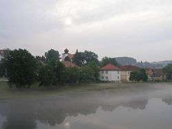 Left bank of the Vltava River in Kamýk | |||
| |||
 Kamýk nad Vltavou Location in the Czech Republic | |||
| Coordinates: 49°38′N 14°15′E / 49.633°N 14.250°ECoordinates: 49°38′N 14°15′E / 49.633°N 14.250°E | |||
| Country |
| ||
| Region | Central Bohemian Region | ||
| District | Příbram District | ||
| Time zone | UTC+1 (CET) | ||
| • Summer (DST) | UTC+2 (CEST) | ||


Kamýk nad Vltavou is a village and municipality in Příbram District in the Central Bohemian Region of the Czech Republic. It lies on the Vltava River.
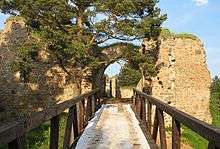
Vrškamýk - ruins of the castle near Kamýk nad Vltavou
Notes
- This article was initially translated from the Czech Wikipedia.
| Wikimedia Commons has media related to Kamýk nad Vltavou. |
References
- ↑ "Z historie Kamyku". Obec Kamyk nad Vltavou. Kamyk nad Vltavou. Retrieved 2 February 2017.
This article is issued from
Wikipedia.
The text is licensed under Creative Commons - Attribution - Sharealike.
Additional terms may apply for the media files.