Makerere Kikoni
| Makerere Kikoni | |
|---|---|
| Coordinates: 00°20′06″N 32°34′12″E / 0.33500°N 32.57000°E | |
| Region | Central Uganda |
| District | Kampala District |
| Division | Kampala Central Division |
| Elevation | 1,240 m (4,070 ft) |
| Time zone | UTC+3 (EAT) |
Makerere Kikoni is a neighbourhood located in Makerere.[1][2]
Location
Makerere Kikoni is located in Kawempe Division. It is bordered by Bwaise to the north, Makerere University to the east, Naakulabye to the southwest. Kasubi and Kawaala lie to the west of Makerere. This location lies approximately 2.5 kilometres (1.6 mi), by road, north of Kampala's central business district.[3]
History
Makerere Kikoni was mainly a slum in semi permanent structures. It is now mostly developed with hostels. The genesis of this development is traced to a policy adopted by Makerere University in the early 1990s, to admit private students. These students had to cater for their residence. Some residences were converted into hostels to house the students. In recent years, multi storey blocks have been put up to serve as hostels. Besides the hostels, Makerere kikoni is developed with supermarkets, churches, the most outstanding being University Church Fellowship (UCF), hotels like "The Grand Global hotel", "J Frigh Hotel", and"Sheron Hotel". It also has Schools like "Makerere Modern Secondary School" and "Caltec Academy", as well as residential developments.[1]
 A church in Kikoni
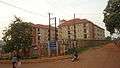 A hostel in Kikoni
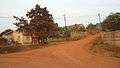 A residential section of kikoni
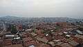 A section of kikoni
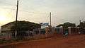 Caltec academy
 Hostels in Kikoni
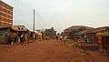 A road in Kikoni
 Aerial view of hostels in Kikoni
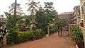 Grand global hotel
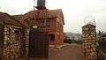 Residential houses in Kikoni
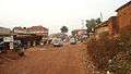 Taxis in Kikoni
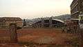 University Christian fellowship
References
- 1 2 "Know your hood: Kikoni, Where student hostels reign supreme" monitor.co.ug. Retrieved March 16, 2015
- ↑ "Poor Disposal of Rubbish in Makerere Kikoni" lizzieflower.wordpress.com. Retrieved March 16, 2015
- ↑ "Makerere Kikoni " maps.google.com. Retrieved March 16, 2015