Maine State Route 237
| |||||||
|---|---|---|---|---|---|---|---|
 | |||||||
| Route information | |||||||
| Maintained by MaineDOT | |||||||
| Length | 8.13 mi[1] (13.08 km) | ||||||
| Existed | 1957 – present | ||||||
| Major junctions | |||||||
| South end |
| ||||||
|
| |||||||
| North end |
| ||||||
| Location | |||||||
| Counties | Cumberland | ||||||
| Highway system | |||||||
| |||||||

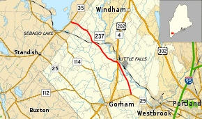
State Route 237 (SR 237) is a state highway located in Cumberland County in southern Maine. It begins at SR 25 in Gorham and runs for 8.13 miles (13.08 km) north to Standish, where it ends at SR 35. The highway functions as a bypass of the towns of Gorham, Windham and Standish.
Route description

SR 237 begins at SR 25 in Gorham, two miles (3.2 km) east of downtown. The route runs northwest, passing through the center of town and crossing over U.S. Route 202 (US 202) / SR 4. SR 237 continues northwest and crosses into the northeastern corner of Standish. The highway immediately terminates at SR 35 near Sebago Lake.
SR 237 runs parallel to, and northeast of, SR 114 (of which SR 237 is a former alignment) over its entire length.[2]
History
SR 237 was originally designated State Route 95 in 1946 over part of a former alignment of SR 114, which now runs parallel to the southwest. It was approximately 10 miles (16 km) in length and similar to the modern route.[3] Following the designation of Interstate 95 in 1957, SR 95 became a duplicate numbering and was subsequently renumbered to SR 237.[4]
Major intersections
The entire route is in Cumberland County.
| Location | mi[1] | km | Destinations | Notes | |
|---|---|---|---|---|---|
| Gorham | 0.00 | 0.00 | |||
| 2.85– 2.90 | 4.59– 4.67 | Roundabout | |||
| Standish | 8.13 | 13.08 | |||
| 1.000 mi = 1.609 km; 1.000 km = 0.621 mi | |||||
References
- 1 2 Maine DOT Map Viewer (Map). Maine Office of GIS. Retrieved October 21, 2017.
- ↑ Google (September 6, 2012). "Overview map of Maine State Route 237" (Map). Google Maps. Google. Retrieved September 6, 2012.
- ↑ Maine State Route Log via floodgap.com
- ↑ Maine State Route Log via floodgap.com
External links
Route map:
