Maine State Route 189
| ||||
|---|---|---|---|---|
 | ||||
| Route information | ||||
| Maintained by MaineDOT | ||||
| Length | 11.25 mi[1] (18.11 km) | |||
| Existed | 1962 (current alignment) – present | |||
| Major junctions | ||||
| West end |
| |||
|
| ||||
| East end |
(Canada–US border) | |||
| Location | ||||
| Counties | Washington | |||
| Highway system | ||||
| ||||

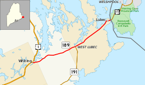
State Route 189 (SR 189) is a numbered state highway in Maine, running from U.S. Route 1 (US 1) in Whiting in the west to the Canada–US border at Lubec in the east. In Lubec the route crosses the Franklin Delano Roosevelt Bridge onto Campobello Island, New Brunswick. SR 189 runs a total of 11 1⁄4 miles (18.1 km).
Route description
SR 189 begins its eastward trek with its intersection with US 1 in Whiting. From the junction, the route generally follows a northeasterly course through Trescott Township (part of the East Central Washington unorganized territory) and West Lubec prior to reaching its eastern terminus at the Franklin Delano Roosevelt Bridge. Via the bridge, SR 189 crosses Johnson Bay into New Brunswick and continues as New Brunswick Route 774.[2]
Major junctions
The entire route is in Washington County.
| Location | mi[1] | km | Destinations | Notes | |
|---|---|---|---|---|---|
| Whiting | 0.00 | 0.00 | |||
| Lubec | 5.73 | 9.22 | Southern terminus of SR 191 | ||
| Lubec Narrows | 11.17– 11.25 | 17.98– 18.11 | Franklin Delano Roosevelt Bridge | ||
| Lubec | 11.25 | 18.11 | New Brunswick provincial line Canada–United States border | ||
| 1.000 mi = 1.609 km; 1.000 km = 0.621 mi | |||||
References
- 1 2 "Maine DOT Map Viewer". Maine Office of GIS. Retrieved July 2, 2017.
- ↑ Google (July 2, 2017). "Maine State Route 189" (Map). Google Maps. Google. Retrieved July 2, 2017.