Mahajanga
| Mahajanga Majunga | ||
|---|---|---|
| District and city | ||
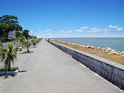 The coast promenade in 2008 | ||
| ||
 Mahajanga Location in Madagascar | ||
| Coordinates: 15°43′S 46°19′E / 15.717°S 46.317°ECoordinates: 15°43′S 46°19′E / 15.717°S 46.317°E | ||
| Country |
| |
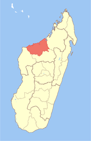
| Region | Boeny | |
| District | Mahajanga District | |
| Commune | Mahajanga | |
| Area | ||
| • Total | 51.05 km2 (19.71 sq mi) | |
| Population (2013) | ||
| • Total | 220,629 | |
| • Density | 4,300/km2 (11,000/sq mi) | |
| Climate | Aw | |

Mahajanga [maːˈdzaŋɡə̥] (French: Majunga) is a city and an administrative district on the northwest coast of Madagascar.
Mahajanga is a favorite tourist destination for Malagasy tourists and international travelers, with beautiful beaches, a coconut-lined boardwalk ("Le Bord", short for "Bord de la mer" or sea-side), and eight months of hot, virtually rain-free weather.
City

The city of Mahajanga (Mahajanga I) is the capital of the Boeny Region. The district (identical to the city) had a population of 220,629 in 2013.[1]
Mahajanga is a seaport, the second most important one in Madagascar after Toamasina. The marine terminal accommodates containerships and small (150 gross ton) general cargo freighters. Because of limited water depth at the wharf, only small ships can call at the terminal. Deeper-draft ships anchor off the terminal and transfer cargoes to and from barges, which move it to and from the terminal.
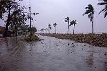
Severe storms during December 2006 damaged the bulkhead, allowing water to flow in and wash backfill out from under the terminal's paving blocks. The resulting collapse of pavement blocks has made operations at the terminal less efficient and reduced the storage space available. The largest and most valuable containerized export is frozen shrimp.
There is an international airport with regional flights to the Comoros and Mayotte.
Mahajanga is on the Betsiboka River, which then leads to Bombetoka Bay.
The city has a sizable Muslim population. In 1977, it was the scene of ethnic unrest, forcing the evacuation of the Comorian minority living there. Mahajanga is also the seat of a Roman Catholic Diocese.
Since 2016, World Christian Broadcasting has operated shortwave radio station MWV (Madagascar World Voice), a sister station of KNLS in Alaska, USA.[2][3][4]
History
Indian community
In the 1780s, a community of roughly 200 Muslim traders from the Indian Subcontinent had formed at Mahajanga at the mouth of the Betsiboka River, according to French traveler Dumaine. Thus, the etymology of the word "Mahajanga" may be Indic. Confusion arose over their legal status; they often declared themselves to be Malagasy subjects to evade the laws against slave-holding or the building of stone houses, both forbidden to British subjects. Their dhows, which they used to transport goods to and from the African mainland, flew French flags. Initial arrivals were mainly Muslim Khojas, Ismailis and Daoudi Bohras, with some Hindus settling later.
The 1911 census found 4,480 Indians in the country, making them 21% of the total foreign population and the second-largest foreign population after the French. Following the nationalisation of private businesses in the 1970s, many were compelled to leave; those who remained were largely uneducated but stayed on and gradually built their businesses. By 2000, they were generally believed to control 50-60% of the country's economy, making them the target of demonstrators during periods of unrest.
In December 2006, a cyclone hit Mahajanga, causing significant damage to the port facilities and to some buildings on or near the coast.
Military history
The city has an airbase which the British used to station Shackleton aircraft to support the Beira Patrol from May 1966.[5]
Surrounding District
Mahajanga II is an administrative district surrounding but separate from the city (which is Mahajanga I). Its population was 77,524 in 2013.[6]
Region
See Boeny.
Climate
Mahajanga has a tropical savanna climate (Köppen Aw) with two distinct seasons: a humid, rainy wet season from November to mid-April, and a sunny, less humid and practically bone-dry dry season for the remaining six-and-a-half months. Cyclones can occur during the wet season, producing very heavy rain and extensive erosion.
| Climate data for Mahajanga | |||||||||||||
|---|---|---|---|---|---|---|---|---|---|---|---|---|---|
| Month | Jan | Feb | Mar | Apr | May | Jun | Jul | Aug | Sep | Oct | Nov | Dec | Year |
| Average high °C (°F) | 31.1 (88) |
30.8 (87.4) |
32.0 (89.6) |
32.5 (90.5) |
32.0 (89.6) |
31.0 (87.8) |
30.8 (87.4) |
31.4 (88.5) |
32.1 (89.8) |
32.5 (90.5) |
32.2 (90) |
31.3 (88.3) |
31.6 (88.9) |
| Daily mean °C (°F) | 27.1 (80.8) |
27.2 (81) |
27.5 (81.5) |
27.4 (81.3) |
26.1 (79) |
24.6 (76.3) |
24.2 (75.6) |
24.6 (76.3) |
25.4 (77.7) |
26.8 (80.2) |
27.7 (81.9) |
27.4 (81.3) |
26.3 (79.3) |
| Average low °C (°F) | 23.6 (74.5) |
23.8 (74.8) |
23.6 (74.5) |
22.9 (73.2) |
20.6 (69.1) |
18.6 (65.5) |
18.0 (64.4) |
18.4 (65.1) |
19.6 (67.3) |
22.0 (71.6) |
23.5 (74.3) |
23.7 (74.7) |
21.5 (70.7) |
| Average rainfall mm (inches) | 401.7 (15.815) |
385.9 (15.193) |
196.3 (7.728) |
69.7 (2.744) |
8.6 (0.339) |
0.7 (0.028) |
1.8 (0.071) |
2.9 (0.114) |
2.3 (0.091) |
9.9 (0.39) |
118.0 (4.646) |
278.2 (10.953) |
1,476 (58.112) |
| Average rainy days (≥ 1.0 mm) | 17 | 16 | 12 | 4 | 1 | 1 | 1 | 1 | 1 | 2 | 6 | 13 | 75 |
| Average relative humidity (%) | 82 | 83 | 81 | 73 | 67 | 64 | 62 | 60 | 63 | 66 | 72 | 80 | 71 |
| Mean monthly sunshine hours | 209.0 | 184.9 | 244.8 | 269.9 | 294.9 | 282.9 | 291.5 | 303.1 | 307.0 | 319.7 | 288.2 | 227.3 | 3,223.2 |
| Source #1: NOAA[7] | |||||||||||||
| Source #2: Weltwetter Spiegel Online (humidity)[8] | |||||||||||||
Education
French international schools:
- Collège français Françoise-Dolto[9]
Literature
- Dr. Michael Flach, Corina Haase, MADAGASIKARA - Insel meiner Traeume, Exclusivefotografy, 11/2007, 208 pages, Picturebook, ISBN 978-3-935971-40-9, Madagaskar in pictures - Exclusivefotografy
- R. J. Barendse, Arabian Seas 1700-1763: The Western Indian Ocean in the eighteenth century
- Du Maine, Idée de la côte orientale de Madagascar, Paris, 1792.
References
- ↑ Institut National de la Statistique, Madagascar
- ↑ | Northsidecoc.org "Madagascar World Voice dedication" (July 14, 2016)
- ↑ | Mount Evelyn DX Report "African site draws close to start" (February 12, 2015)
- ↑ | Christian Chronicle "After a decade of perseverance, Madagascar World Voice debuts" (May 18, 2016)
- ↑ Spence, Daniel Owen (2015). A History of the Royal Navy: Empire and Imperialism. London: I.B.Tauris.
- ↑ Institut National de la Statistique, Madagascar.
- ↑ "Majunga/Mahajanga Climate Normals 1961–1990". National Oceanic and Atmospheric Administration. Retrieved October 19, 2015.
- ↑ "Wetter im Detail: Klimadaten". Spiegel Online. 2012. Retrieved on July 19, 2012.
- ↑ "Collège français Françoise-Dolto." AEFE. Retrieved on May 7, 2015.