Magyarszerdahely
| Magyarszerdahely | ||
|---|---|---|
| ||
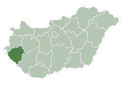
 Magyarszerdahely Location of Magyarszerdahely | ||
| Coordinates: 46°33′16″N 16°56′14″E / 46.55457°N 16.93710°ECoordinates: 46°33′16″N 16°56′14″E / 46.55457°N 16.93710°E | ||
| Country |
| |
| County | Zala | |
| Area | ||
| • Total | 16.22 km2 (6.26 sq mi) | |
| Population (2004) | ||
| • Total | 559 | |
| • Density | 34.46/km2 (89.3/sq mi) | |
| Time zone | UTC+1 (CET) | |
| • Summer (DST) | UTC+2 (CEST) | |
| Postal code | 8776 | |
| Area code(s) | 93 | |

Magyarszerdahely is a village in Zala County, Hungary.
External links
- Street map (in Hungarian)
.svg.png)
This article is issued from
Wikipedia.
The text is licensed under Creative Commons - Attribution - Sharealike.
Additional terms may apply for the media files.