Magapit Suspension Bridge
| Magapit Suspension Bridge | |
|---|---|
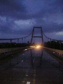 Magapit Suspension Bridge at dusk in 2007. | |
| Coordinates | 18°07′20″N 121°40′22″E / 18.122258°N 121.672672°ECoordinates: 18°07′20″N 121°40′22″E / 18.122258°N 121.672672°E |
| Crosses | Cagayan River |
| Locale | Cagayan |
| Official name | Magapit Suspension Bridge |
| Other name(s) | Magapit Bridge |
| Maintained by | Department of Public Works and Highways |
| Characteristics | |
| Design | Suspension Bridge |
| Total length | 449.14m |
| Longest span | 257 m |
| Load limit | 20 Tons |
| History | |
| Construction end | 1978 |
| Opened | 1978 |
| Statistics | |
| Daily traffic | 2 lanes of vehicular traffic; pedestrian sidewalks |
The Magapit Bridge is suspension bridge that opened in 1978 to connect the east and west sides of the Cagayan River in the province of Cagayan. It is located in Magapit, Lal-lo, Cagayan, Philippines. The bridge was also named by the locals as the "Golden Gate of Cagayan". This bridge is one of the only two bridges in the province that runs across the mighty waterway of the Cagayan River.
The late Engr. Angel G. Villanueva was the project engineer of Magapit suspension bridge under IWCDC (owned by the Dys) and Japanese consultants.
Rehabilitation
The bridge undergone rehabilitation that started in May 16, 2012 and ended November 20, 2012. Traffic in that area were serviced by ferry boats in lieu of the rehabilitation. The rehabilitation project had an estimated cost of 100 million pesos. [1]
References
- ↑ DPWH: Magapit Bridge closed starting May 16 for repair "Archived copy". Archived from the original on 2012-08-05. Retrieved 2012-05-28.
This article is issued from
Wikipedia.
The text is licensed under Creative Commons - Attribution - Sharealike.
Additional terms may apply for the media files.