Madolenihmw
Map of Pohnpei Island showing the municipalities.
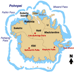
Madolenihmw is one of the administrative divisions of the Micronesian island of Pohnpei. It is located in the central east of the island, to the east of Mount Nahna Laud and south of Mount Kapwuriso. The coast of Madolenihmw includes a large bay which contains the island of Temwen, famous for its Nan Madol ruins.
Climate
Education
Pohnpei State Department of Education operates public schools:
- Madolenihmw High School
- ESDM Elementary School[1]
- Lukop Elementary School[1]
- Mand Elementary School[1]
- Pohnlangas Elementary School[1]
- Sapwalap Elementary School[1]
- Temwen Elementary School[1]
- Wapar Elementary School[1]
Private schools:[2]
- Ohwa Christian High School
See also
References
Bendure, G., & Friary, N. (1988) Micronesia: A travel survival kit. South Yarra, Australia: Lonely Planet.
Coordinates: 6°49′15″N 158°18′10″E / 6.82083°N 158.30278°E
- 1 2 3 4 5 6 7 "Pohnpei Schools." Pohnpei State Department of Education. Retrieved on February 23, 2018.
- ↑ "Higher Education in the Federated States of Micronesia." Embassy of the Federated States of Micronesia Washington DC. Retrieved on February 23, 2018.
This article is issued from
Wikipedia.
The text is licensed under Creative Commons - Attribution - Sharealike.
Additional terms may apply for the media files.