Madaba Map
Coordinates: 31°43′3.54″N 35°47′39.12″E / 31.7176500°N 35.7942000°E
The Madaba Map (also known as the Madaba Mosaic Map) is part of a floor mosaic in the early Byzantine church of Saint George in Madaba, Jordan. The Madaba Map is a map of the Middle East. Part of it contains the oldest surviving original cartographic depiction of the Holy Land and especially Jerusalem. It dates to the 6th century AD.
History

The Madaba Mosaic Map depicts Jerusalem with the Nea Church, which was dedicated on 20 November, AD 542. Buildings erected in Jerusalem after 570 are absent from the depiction, thus limiting the date range of its creation to the period between 542 and 570. The mosaic was made by unknown artists, probably for the Christian community of Madaba, which was the seat of a bishop at that time. In 614, Madaba was conquered by the Persian empire. In the 8th century AD, the Muslim Umayyad rulers had some figural motifs removed from the mosaic. In 746, Madaba was largely destroyed by an earthquake and subsequently abandoned. The mosaic was rediscovered in 1884, during the construction of a new Greek Orthodox church on the site of its ancient predecessor.[1] Patriarch Nicodemus I of Jerusalem was informed, but no research was carried out until 1896.[2][3]
In the following decades, large portions of the mosaic map were damaged by fires, activities in the new church and by the effects of moisture. In December 1964, the Volkswagen Foundation gave the Deutscher Verein für die Erforschung Palästinas ("German Society for the exploration of Palestine") 90,000 DM to save the mosaic. In 1965, the archaeologists Heinz Cüppers and Herbert Donner undertook the restoration and conservation of the remaining parts of the mosaic.
Description
The floor mosaic is located in the apse of the church of Saint George at Madaba. It is not oriented northwards, like modern maps, but faces east towards the altar in such a fashion that the position of places on the map coincides with the actual compass directions. Originally, it measured 21 by 7 m and contained over two million tesserae.[4] Its current dimensions are 16 by 5 m.
Topographic representation
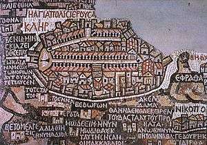
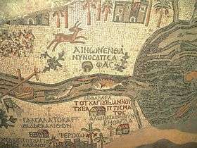
The mosaic map depicts an area from Lebanon in the north to the Nile Delta in the south, and from the Mediterranean Sea in the west to the Eastern Desert. Among other features, it depicts the Dead Sea with two fishing boats, a variety of bridges linking the banks of the Jordan, fish swimming in the river and receding from the Dead Sea; a lion (rendered nearly unrecognisable by the insertion of random tesserae during a period of iconoclasm) hunting a gazelle in the Moab desert, palm-ringed Jericho, Bethlehem and other biblical-Christian sites. The map may partially have served to facilitate pilgrims' orientation in the Holy Land. All landscape units are labelled with explanations in Greek. A combination of folding perspective and aerial view depicts about 150 towns and villages, all of them labelled.
The largest and most detailed element of the topographic depiction is Jerusalem, at the centre of the map. The mosaic clearly shows a number of significant structures in the Old City of Jerusalem: the Damascus Gate, the Lions' Gate, the Golden Gate, the Zion Gate, the Church of the Holy Sepulchre, the New Church of the Theotokos, the Tower of David and the Cardo Maximus. The recognisable depiction of the urban topography makes the mosaic a key source on Byzantine Jerusalem. Also unique are the detailed depictions of cities such as Neapolis, Askalon, Gaza, Pelusium and Charachmoba, all of them nearly detailed enough to be described as street maps.
Scientific significance
The mosaic map of Madaba is the oldest known geographic floor mosaic in art history. It is used heavily for the localisation and verification of biblical sites. Study of the map played a major role in answering the question of the topographical location of Askalon (Asqalan on the map).[5] In 1967, excavations in the Jewish Quarter of Jerusalem revealed the Nea Church and the Cardo Maximus in the very locations suggested by the Madaba Map.[6]
In February 2010, excavations further substantiated its accuracy with the discovery of a road depicted in the map that runs through the center of Jerusalem.[7] According to the map, the main entrance to the city was through a large gate opening into a wide central street. Until the discovery, archaeologists were not able to excavate this site due to heavy pedestrian traffic. In the wake of infrastructure work near the Jaffa Gate, large paving stones were discovered at a depth of 4 meters below ground that prove such a road existed.[8]
Copies of the Madaba Map
A copy of the map is in the collection of the Archaeological Institute at Göttingen University. It was produced during the conservation work at Madaba in 1965 by archaeologists of the Rheinisches Landesmuseum, Trier. A copy produced by students of the Madaba Mosaic School is in the foyer of the Akademisches Kunstmuseum at Bonn. The lobby of the YMCA in Jerusalem has a replica of the map incorporated in the floor.[9]
References
- ↑ Meimaris, Yiannis. "The Discovery of the Madaba Mosaic Map. Mythology and Reality". Archived from the original on 3 October 2013. Retrieved 9 June 2011.
- ↑ Donner, 1992, p.11
- ↑ Jordan Times, "The discovery of the mosaic map of madaba", September 21, 1995: "It was only Abuna Kleofas Kikilides who realised the true significance, for the history of the region, that the map had while visiting Madaba in December 1896. A Franciscan friar of ltalian-Croatian origin born in Constantinople, Fr. Girolamo Golubovich, helped Abuna Kleofas to print a booklet in Greek about the map at the Franciscan printing press of Jerusalem. Immediately afterwards, the Revue Biblique published a long and detailed historic-geographic study of the map by the Dominican fathers M.J. Lagrange and H. Vincent after visiting the site themselves. At the same time. Father J. Germer-Durand of the Assumptionist Fathers published a photographic album with his own pictures of the map. In Paris, C. Clermont-Gannau, a well known oriental scholar, announced the discovery at the Academie des Sciences et belles Lettres. "
- ↑ http://www.uni-bonn.de/Aktuelles/Publikationen/forsch/forsch_4_November_2005/bilder/Kultur.pdf%5Bpermanent+dead+link%5D Ute Friederich: Antike Kartographie
- ↑ Jana Vogt: Architekturmosaiken am Beispiel der drei jordanischen Städte Madaba, Umm al-Rasas und Gerasa. Ernst-Moritz-Arndt-Universität Greifswald, Greifswald 2004
- ↑ ARCHEOLOGICAL SITES NO. 5 Jerusalem- the Nea Church and the Cardo
- ↑ "Archaeologists find Byzantine era road". CNN. 11 February 2010.
- ↑ Dig uncovers ancient Jerusalem street depicted on Byzantine map
- ↑ Jerusalem: Architecture in the British Mandate Period
Bibliography
Early sources
Later sources
- Madden, Andrew M., "A New Form of Evidence to Date the Madaba Map Mosaic," Liber Annuus 62 (2012), 495-513.
- Hepper, Nigel; Taylor, Joan, "Date Palms and Opobalsam in the Madaba Mosaic Map," Palestine Exploration Quarterly, 136,1 (April 2004), 35-44.
- Herbert Donner: The Mosaic Map of Madaba. Kok Pharos Publishing House, Kampen 1992, ISBN 90-390-0011-5
- Herbert Donner; Heinz Cüppers (1977). Die Mosaikkarte von Madeba: Tafelband; Abhandlungen des Deutschen Palästinavereins 5. Otto Harrassowitz Verlag. ISBN 978-3-447-01866-1.
- Michael Avi-Yonah: The Madaba mosaic map. Israel Exploration Society, Jerusalem 1954
- Michele Piccirillo: Chiese e mosaici di Madaba. Studium Biblicum Franciscanum, Collectio maior 34, Jerusalem 1989 (Arabische Edition: Madaba. Kana'is wa fusayfasa', Jerusalem 1993)
- Kenneth Nebenzahl: Maps of the Holy Land, images of Terra Sancta through two millennia. Abbeville Press, New York 1986, ISBN 0-89659-658-3
- Adolf Jacoby: Das geographische Mosaik von Madaba, Die älteste Karte des Heiligen Landes. Dieterich’sche Verlagsbuchhandlung, Leipzig 1905
- Weitzmann, Kurt, ed., Age of spirituality: late antique and early Christian art, third to seventh century, no. 523, 1979, Metropolitan Museum of Art, New York, ISBN 9780870991790
External links
| Wikimedia Commons has media related to Madaba map. |
- Article on the map and its Göttingen copy (in German)1999 (PDF)
- The Madaba Map
- The Madaba Mosaic Map at the Franciscan Archaeological Institute
- Madaba Mosaic Map web page at San Francisco State University
- Byzantine Jerusalem and the Madaba Map
- Madaba Map at Bibleplaces.com