Macquarie Park, New South Wales
| Macquarie Park Sydney, New South Wales | |||||||||||||||
|---|---|---|---|---|---|---|---|---|---|---|---|---|---|---|---|
 Macquarie Centre | |||||||||||||||
| Population | 8,144 (2016 census)[1] | ||||||||||||||
| • Density | 1,198/km2 (3,102/sq mi) | ||||||||||||||
| Established | 5 February 1999[2] | ||||||||||||||
| Postcode(s) | 2113 | ||||||||||||||
| Area | 6.8 km2 (2.6 sq mi) | ||||||||||||||
| Location | 15 km (9 mi) north-west of Sydney CBD | ||||||||||||||
| LGA(s) | City of Ryde | ||||||||||||||
| State electorate(s) | Ryde, Lane Cove | ||||||||||||||
| Federal Division(s) | Bennelong | ||||||||||||||
| |||||||||||||||
M2_Motorway.jpg)

Sports_Fields_Culloden_Road-2.jpg)
Macquarie Park (/məˈkwɒri/) is a suburb in northern Sydney, New South Wales, Australia. Macquarie Park is located 15 kilometres north-west of the Sydney central business district in the local government area of the City of Ryde. Macquarie Park is part of the Northern Suburbs region.
Macquarie Park was and still is part of the suburb of North Ryde until it was gazetted as a suburb in its own right on 5 February 1999,[2] and many businesses still use North Ryde as the address. Both suburbs share the 2113 postcode but Macquarie University, which is located at the northern part of the suburb, has its own postcode of 2109.
Aboriginal culture
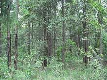
The whole area between the Parramatta and Lane Cove Rivers was originally known by its Aboriginal name Wallumatta. Contact with the first white settlement's bridgehead into Australia quickly devastated much of the population through epidemics of smallpox and other diseases. Their descendants live on, though their language, social system, way of life and traditions are mostly lost. The Aboriginal name survives in a local reserve, the Wallumatta Nature Reserve, located at the corner of Twin and Cressy roads, North Ryde. Very few remnants of Sydney Turpentine-Ironbark Forest still exist. The most substantial undisturbed area is the Wallumatta Nature Reserve in North Ryde, which is owned and managed by the National Parks and Wildlife Service. This small and critically endangered reserve, also known as the Macquarie Hospital Bushland, is one of the last remnants of the remaining 0.5% (as at 2007)[3] of original and endangered[4] turpentine-ironbark forests on Wianamatta shale soil in Sydney.[5] See Sydney Turpentine-Ironbark Forest.
History
Macquarie Park is located within what was once the larger suburb of North Ryde.
Macquarie Park is named for Governor Lachlan Macquarie (1762–1824), a British military officer and colonial administrator who served as the Governor of New South Wales from 1810 to 1821. The area that is now Macquarie Park was part of the suburb of North Ryde from the late 19th century. The area was once filled with market gardens, poultry farms and vast tracts of bushland, with many beautiful picnic spots and waterfalls.
The mid-1960s saw the establishment of Macquarie University and the 'Macquarie Park Employment Area' which saw the rezoning of 'Green Belt' bushland to allow for industrial activities. The initial concept for Macquarie Park was based on the idea of a similar hi-tech industrial area surrounding Stanford University in Palo Alto, California, the goal being to provide for the interaction between industries and the university.[6]
During the 1970s, companies such as Amalgamated Wireless Australasia Limited, Beiersdorf, Racal and Universal Press located their corporate headquarters in the area. Macquarie Park has since gained a reputation of being a leading high-tech industrial area in Australia. It attracts many local and international companies from high-tech fields including electronic, scientific, computing, medical, communication, pharmaceutical and business supply solutions.
Commercial area
Macquarie Park is an important centre for business in Australia and the state of New South Wales. The corporate prestige, close access to facilities and aesthetically pleasing environment are an attraction for many corporations. Macquarie Park had a total number of 32 308 jobs in 2001, making it the fourth largest concentration of jobs in NSW after Sydney CBD, North Sydney and Parramatta. Large businesses in the suburb include: AC Neilsen, Avaya, AstraZeneca, BOC, Canon, CA, Compuware, Australian Radio Network: 101.7 WSFM & Edge 96.1,[7] CSC, Kyocera, Fujitsu, Fuji Xerox, Ford Motor Co/Premiere Automotive Group (Aston Martin, Jaguar, Volvo, Land Rover), Foxtel, General Motors (Holden & Saab), George Weston Foods, Hitachi, Hyundai, Johnson & Johnson, Kenwood, Kimberly-Clark, Lucent Technologies, Metcash, Microsoft, Nestle Purina, Nortel Networks, Novartis, Bilfinger Berger, Optus[8] (moved in late 2007 from North Sydney),[9] Oracle Corporation, Orix, Philips, Raytheon, Sanofi-Aventis, Siemens, Memjet, Smiths Medical, Sony, Toshiba, TPG Telecom, Warner Music Group, Wesfarmers Industrial & Safety. Businesses that have previously operated in Macquarie Park include Mix 106.5 (until 2006 when it moved to Hornsby), Network Ten (until 1991 when it moved to Ultimo then Pyrmont in 1996) and Global Television Network Studios (until mid-2007).
The Macquarie Centre is a major regional shopping Centre at Macquarie Park. Macquarie University takes up a large part of the suburb.
A substantial re-development of the Macquarie University Station Precinct (also known as the Herring Road Precinct) in Macquarie Park is planned as part of the NSW state government's "Priority Growth Precincts" program (originally known as the "Urban Activation Precincts" program). The objective is to provide housing and employment close to transport to help meet Sydney's growth needs, including up to 2,400 new homes by 2021 and up to 5,800 by 2031 that are within a ten-minute walk from Macquarie University Station. Following public display and consultation, the rezoning proposal was finalised in September 2015.[10][11]
Transport
Macquarie Park has access to the M2 Hills Motorway, that runs through the northern part of the suburb. It is serviced by Busways, Forest Coach Lines, Hillsbus, State Transit and Transdev NSW bus services.
During peak hour, the whole area gets very congested with traffic.
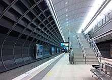
Macquarie Park railway station, Macquarie University railway station and North Ryde railway station are underground stations on the Epping to Chatswood rail line previously operated by the Sydney Trains network. The line opened on 23 February 2009 and closed for metro conversion on September 30, 2018. These stations are to be reopened in early 2019 as part of Sydney Metro Northwest.
At the 2011 census, only 27.3% of employed people travelled to work on public transport and 42.4% by car (either as driver or as passenger).
Education
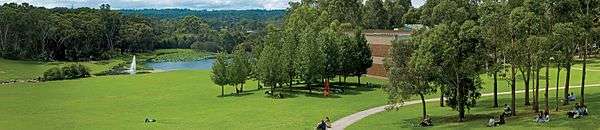
Macquarie University is one of Australia's largest universities. It features a 126-hectare park-like campus beside a high-technology corridor.[12]
The University is affiliated with a number of colleges also located in the suburb including Dunmore Lang College,[13] Robert Menzies College [14] an Anglican college, Macquarie Christian Studies Institute [15] and Sydney Institute of Business & Technology.[16]
Macquarie University has in recent years become a major research centre, with Macquarie University Hospital and the Cochlear Research Centre located within the university grounds.
Excelsia College moved to a Macquarie Park campus in 2016.[17]
Demographics
At the 2016 census, Macquarie Park recorded a population of 8,144. Of these:[1]
- Age distribution
- In keeping with its proximity to the university, Macquarie Park shows an over-representation of younger adults compared to the rest of the country. Macquarie Park residents' median age was 29 years, compared to the national median of 38. Children aged 0–14 years made up just 10.7% of the population (compared to the national average of 18.7%) and people aged 65 years and over made up 8.1% of the population (national average is 15.8%).
- Ethnic diversity
- 31.8% of people were born in Australia. The most common countries of birth were China 14.8%, India 9.4%, South Korea 3.1%, Philippines 2.9% and Hong Kong 2.6%. However, only 10.2% identify their ethnic ancestry as Australian; the other most common self-identified ancestries were Chinese 20.8%, English 12.6%, Indian 9.4% and Irish 4.2%. 35.5% of people only spoke English at home. Other languages spoken at home included Mandarin 15.5%, Cantonese 4.8%, Hindi 4.5%, Korean 3.4% and Indonesian 2.1%.
- Religion
- This is an optional question on the Census. Of the people who answered it, the most common responses were No Religion 33.8% and Catholic 13.8%.
- Income
- The median weekly household income was $1,631, higher than the national average of $1,438.
- Housing
- Most private dwellings (79.6%) were flats, units or apartments. A further 18.8% were semi-detached (townhouses etc.). 58.3% were family households, 31.8% were single person households and 9.8% were group households. The average household size was 2.1 people.
Politics
Macquarie Park is in the State of New South Wales electorates of Lane Cove and Ryde, and the Federal electorate of Division of Bennelong.
Climate
Macquarie Park has a warm temperate climate with warm to hot summers and cool, damp winters. The record low of −3.5 °C (26 °F) was recorded 30 years ago, on 28 July 1986. The record maximum temperature was recorded more recently, on 21 December 1994 when the temperature reached 43.1 °C (110 °F).
| Climate data for Macquarie Park | |||||||||||||
|---|---|---|---|---|---|---|---|---|---|---|---|---|---|
| Month | Jan | Feb | Mar | Apr | May | Jun | Jul | Aug | Sep | Oct | Nov | Dec | Year |
| Record high °C (°F) | 41.5 (106.7) |
41.4 (106.5) |
40.7 (105.3) |
33.5 (92.3) |
28.5 (83.3) |
24.8 (76.6) |
26.0 (78.8) |
30.1 (86.2) |
34.4 (93.9) |
39.1 (102.4) |
42.0 (107.6) |
43.1 (109.6) |
43.1 (109.6) |
| Average high °C (°F) | 27.7 (81.9) |
27.4 (81.3) |
25.9 (78.6) |
23.4 (74.1) |
20.3 (68.5) |
17.4 (63.3) |
17.1 (62.8) |
18.5 (65.3) |
21.1 (70) |
23.3 (73.9) |
24.8 (76.6) |
27.1 (80.8) |
22.8 (73) |
| Average low °C (°F) | 16.9 (62.4) |
16.9 (62.4) |
15.2 (59.4) |
12.0 (53.6) |
9.2 (48.6) |
6.5 (43.7) |
4.9 (40.8) |
5.7 (42.3) |
7.8 (46) |
10.8 (51.4) |
13.0 (55.4) |
15.6 (60.1) |
11.2 (52.2) |
| Record low °C (°F) | 8.5 (47.3) |
8.9 (48) |
6.1 (43) |
2.5 (36.5) |
0.3 (32.5) |
−1.7 (28.9) |
−3.5 (25.7) |
−1.1 (30) |
0.1 (32.2) |
0.9 (33.6) |
1.2 (34.2) |
6.5 (43.7) |
−3.5 (25.7) |
| Average precipitation mm (inches) | 120.1 (4.728) |
144.8 (5.701) |
131.1 (5.161) |
110.8 (4.362) |
86.0 (3.386) |
114.0 (4.488) |
56.3 (2.217) |
53.9 (2.122) |
60.1 (2.366) |
84.5 (3.327) |
93.7 (3.689) |
86.0 (3.386) |
1,141.8 (44.953) |
| Average precipitation days (≥ 0.1 mm) | 12.5 | 13.0 | 13.2 | 10.4 | 10.3 | 10.9 | 8.6 | 7.7 | 8.1 | 10.7 | 13.0 | 11.3 | 129.7 |
| Source: [18] | |||||||||||||
In popular culture
Macquarie Park is also the location for the Lane Cove River Tourist Park where the Australian soap opera Home and Away is partly filmed.
References
- 1 2 Australian Bureau of Statistics (27 June 2017). "Macquarie Park (State Suburbs)". 2016 Census QuickStats. Retrieved 9 September 2017.

- 1 2 "Macquarie Park (suburb)". Geographical Names Register (GNR) of NSW. Geographical Names Board of New South Wales. Retrieved 27 April 2014.
- ↑ City of Ryde Council website, "NATIVE VEGETATION: Sydney Turpentine – Ironbark Forest", dated 1 January 2007. Retrieved 1 July 2007.
- ↑ National Parks and Wildlife Service (New South Wales) "Sydney turpentine-ironbark forest – endangered ecological community listing", 16 October 1998. Retrieved 1 July 2007.
- ↑ Wallumatta Nature Reserve National Parks and Wildlife Service(information page). Retrieved 1 July 2007.
- ↑ The Book of Sydney Suburbs, Compiled by Frances Pollon, Angus & Robertson Publishers, 1990, Published in Australia ISBN 0-207-14495-8, page 189
- ↑ "3 Byfield Street, Macquarie Park: Key Property Information". Stockland. Archived from the original on 13 March 2008. Retrieved 2008-04-09.
- ↑ "Optus Centre, Macquarie Park: Key Property Information". Stockland. Archived from the original on 11 March 2008. Retrieved 2008-04-09.
- ↑ "Optus campus is a showcase of innovation". The Northern District Times. 2007-07-18. Retrieved 2008-04-09.
- ↑ "Urban Activation Precinct - Herring Road, Macquarie Park". NSW Department of Planning and Infrastructure. Retrieved 23 April 2014.
- ↑ "Frequently Asked Questions: Macquarie University Station Precinct" (PDF). Department of Planning & Environment, State Government of New South Wales. Retrieved 9 December 2015.
- ↑ "Macquarie University". Retrieved 3 September 2011.
- ↑ "Dunmore Lang College". Retrieved 3 September 2011.
- ↑ "Robert Menzies College". Retrieved 3 September 2011.
- ↑ "Macquarie Christian Studies Institute". Archived from the original on 28 March 2010. Retrieved 3 September 2011.
- ↑ "Sydney Institute of Business & Technology". Retrieved 3 September 2011.
- ↑ Steven Deare, (16 February 2016), Excelsia College, formerly Wesley Institute, opens at Macquarie Park, Northern District Times Retrieved 11 March 2016
- ↑ "Climate statistics for". Bureau of Meteorology. Retrieved 9 February 2014.
External links
| Wikimedia Commons has media related to Macquarie Park, New South Wales. |

Coordinates: 33°46′38″S 151°07′27″E / 33.77720°S 151.12412°E