Macopin, New Jersey
| Macopin, New Jersey | |
|---|---|
| Unincorporated community | |
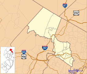 Macopin, New Jersey Macopin's location in Passaic County (Inset: Passaic County in New Jersey)  Macopin, New Jersey Macopin, New Jersey (New Jersey)  Macopin, New Jersey Macopin, New Jersey (the US) | |
| Coordinates: 41°03′08″N 74°23′20″W / 41.05222°N 74.38889°WCoordinates: 41°03′08″N 74°23′20″W / 41.05222°N 74.38889°W | |
| Country |
|
| State |
|
| County | Passaic |
| Township | West Milford |
| Elevation | 1,004 ft (306 m) |
| ZIP code | 07480 |
| GNIS feature ID | 0878011[1] |
Macopin is an unincorporated community located within West Milford Township in Passaic County, New Jersey, United States.[2] The area is served as United States Postal Service ZIP Code 07480.
As of the 2000 United States Census, the population for ZIP Code Tabulation Area 07480 was 16,029.
References
- ↑ "Macopin". Geographic Names Information System. United States Geological Survey. Retrieved 2012-09-23.
- ↑ Locality Search, State of New Jersey. Accessed June 9, 2016.
External links
Municipalities and communities of Passaic County, New Jersey, United States | ||
|---|---|---|
| Cities | 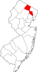 | |
| Boroughs | ||
| Townships | ||
| CDPs | ||
| Other unincorporated communities | ||
This article is issued from
Wikipedia.
The text is licensed under Creative Commons - Attribution - Sharealike.
Additional terms may apply for the media files.