Mýto
| Mýto | |||
| Town | |||
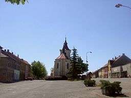 Town square in Mýto | |||
|
|||
| Name origin: toll, charge for road use | |||
| Country | Czech Republic | ||
|---|---|---|---|
| Region | Plzeň | ||
| District | Rokycany | ||
| Commune | Rokycany | ||
| Elevation | 443 m (1,453 ft) | ||
| Coordinates | 49°47′21″N 13°44′06″E / 49.78917°N 13.73500°ECoordinates: 49°47′21″N 13°44′06″E / 49.78917°N 13.73500°E | ||
| Area | 17.79 km2 (6.87 sq mi) | ||
| Population | 1,518 (2016-01-01) | ||
| Density | 85/km2 (220/sq mi) | ||
| First mentioned | 1336 | ||
| Mayor | František Končel | ||
| Timezone | CET (UTC+1) | ||
| - summer (DST) | CEST (UTC+2) | ||
| Postal code | 338 05 | ||
| Free | < | ||
  Location in the Czech Republic | |||
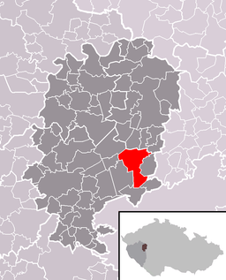 Location of Mýto within Rokycany District | |||
| Wikimedia Commons: Mýto | |||
| Statistics: statnisprava.cz | |||
| Website: www.mestomyto.cz | |||
Mýto, fully Mýto v Čechách (Czech pronunciation: [ˈmiːto]; German: Mauth) is a town in the Czech Republic.
History
Until 1918, Mýto was part of the Austrian monarchy (Austria side after the compromise of 1867), in the Rokycany district, one of the 94 Bezirkshauptmannschaften in Bohemia.[1]

Austrian KK stamp, issue 1867, cancelled MAUTH
People
- August Wilhelm Ambros (1816–1876), Austrian music historian[2]
- Family (names) like Mauthner, Mautner
References
- ↑ Die postalischen Abstempelungen auf den österreichischen Postwertzeichen-Ausgaben 1867, 1883 und 1890, Wilhelm KLEIN, 1967
- ↑ de:August Wilhelm Ambros
External links
| Wikimedia Commons has media related to Mýto. |
This article is issued from
Wikipedia.
The text is licensed under Creative Commons - Attribution - Sharealike.
Additional terms may apply for the media files.