Münchwilen District
| Münchwilen District Bezirk Münchwilen | |
|---|---|
| District | |
 | |
| Country |
|
| Canton |
|
| Capital | Münchwilen |
| Area | |
| • Total | 155.86 km2 (60.18 sq mi) |
| Population (2016) | |
| • Total | 46,449 |
| • Density | 300/km2 (770/sq mi) |
| Time zone | UTC+1 (CET) |
| • Summer (DST) | UTC+2 (CEST) |
| Municipalities | 13 |
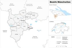
Münchwilen District is one of the five districts of the canton of Thurgau, Switzerland. It has a population of 46,449 (as of 31 December 2016).[1] Its capital is the town of Münchwilen.
The district contains the following municipalities:
| Coat of arms | Municipality | Population (31 December 2016)[1] |
Area km²[2] |
|---|---|---|---|
| Aadorf | 8,865 | 20.0 | |
| Bettwiesen | 1,177 | 3.85 | |
| Bichelsee-Balterswil | 2,826 | 12.27 | |
| Braunau | 763 | 9.19 | |
| Eschlikon | 4,309 | 6.20 | |
| Fischingen | 2,686 | 30.67 | |
| Lommis | 1,217 | 8.63 | |
| Münchwilen | 5,377 | 7.78 | |
| Rickenbach | 2,773 | 1.57 | |
| Sirnach | 7,738 | 12.43 | |
| Tobel-Tägerschen | 1,596 | 7.07 | |
| Wängi | 4,632 | 16.41 | |
| Wilen | 2,490 | 2.26 | |
| Total (13) | 46,449 | 138.22 |
References
- 1 2 Swiss Federal Statistical Office - STAT-TAB, online database – Ständige und nichtständige Wohnbevölkerung nach institutionellen Gliederungen, Geburtsort und Staatsangehörigkeit (in German) accessed 30 August 2017
- ↑ Swiss Federal Statistical Office-Land Use Statistics 2009 data (in German) accessed 25 March 2010
This article is issued from
Wikipedia.
The text is licensed under Creative Commons - Attribution - Sharealike.
Additional terms may apply for the media files.