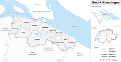
Kreuzlingen District
| Kreuzlingen District Bezirk Kreuzlingen | |
|---|---|
| District | |
 | |
| Country |
|
| Canton |
|
| Capital | Kreuzlingen |
| Area | |
| • Total | 129.0 km2 (49.8 sq mi) |
| Population (2016) | |
| • Total | 47,132 |
| • Density | 370/km2 (950/sq mi) |
| Time zone | UTC+1 (CET) |
| • Summer (DST) | UTC+2 (CEST) |
| Municipalities | 14 |
Kreuzlingen District is one of the five districts of the canton of Thurgau in Switzerland. It has a population of 47,132 (as of 31 December 2016).[1] Its capital is the city of Kreuzlingen.
The district contains the following municipalities:
| Coat of arms | Municipality | Population (31 December 2016)[1] |
Area km²[2] |
|---|---|---|---|
| Altnau | 2,161 | 6.7 | |
| Bottighofen | 2,188 | 2.4 | |
| Ermatingen | 3,308 | 10.4 | |
| Gottlieben | 326 | 0.4 | |
| Güttingen | 1,568 | 9.5 | |
| Kemmental | 2,465 | 28.4 | |
| Kreuzlingen | 21,560 | 11.5 | |
| Langrickenbach | 1,285 | 10.9 | |
| Lengwil | 1,686 | 8.9 | |
| Münsterlingen | 3,333 | 5.4 | |
| Raperswilen | 391 | 7.7 | |
| Salenstein | 1,288 | 6.6 | |
| Tägerwilen | 4,524 | 11.6 | |
| Wäldi | 1,049 | 12.3 | |
| Total (14) | 47,132 | 129.0 |
References
- 1 2 Swiss Federal Statistical Office - STAT-TAB, online database – Ständige und nichtständige Wohnbevölkerung nach institutionellen Gliederungen, Geburtsort und Staatsangehörigkeit (in German) accessed 30 August 2017
- ↑ Swiss Federal Statistical Office-Land Use Statistics 2009 data (in German) accessed 25 March 2010
This article is issued from
Wikipedia.
The text is licensed under Creative Commons - Attribution - Sharealike.
Additional terms may apply for the media files.