Ménilmontant (Paris Métro)
Ménilmontant | |||||||||||
|---|---|---|---|---|---|---|---|---|---|---|---|
| Paris Métro station | |||||||||||
 | |||||||||||
| Location |
139, boul. de Ménilmontant 11th arrondissement of Paris Île-de-France France | ||||||||||
| Coordinates | 48°51′58″N 2°23′01″E / 48.866248°N 2.383618°ECoordinates: 48°51′58″N 2°23′01″E / 48.866248°N 2.383618°E | ||||||||||
| Owned by | RATP | ||||||||||
| Operated by | RATP | ||||||||||
| Other information | |||||||||||
| Fare zone | 1 | ||||||||||
| History | |||||||||||
| Opened | 31 January 1903 | ||||||||||
| Services | |||||||||||
| |||||||||||
| Location | |||||||||||
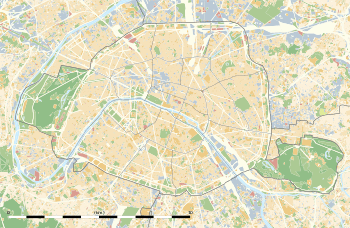 Ménilmontant Location within Paris | |||||||||||
Ménilmontant is a station on Paris Métro Line 2, on the border of the 11th and 20th arrondissements.
History
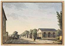
The Barrière de Ménilmontant, a gate of the Wall of the Farmers-General
The station was opened on 31 January 1903 as part of the extension of line 2 (known at the time as "2 Nord") from Anvers to Bagnolet (now called Alexandre Dumas). It is named after the Boulevard de Ménilmontant, which was named after a hamlet, annexed by Belleville before the French Revolution and in turn by Paris in 1860. It was the location of the Barrière de Ménilmontant, a gate built for the collection of taxation as part of the Wall of the Farmers-General; the gate was built between 1784 and 1788 and demolished during the 19th century.[1]
Station layout
| Street Level |
| B1 | Mezzanine for platform connection |
| Platform level | Side platform, doors will open on the right | |
| Platform 1 | ← | |
| Platform 2 | | |
| Side platform, doors will open on the right | ||
Gallery
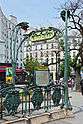 Street-level entrance at Ménilmontant
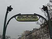 Subway entrance
References
- ↑ "La barrière de Ménilmontant" (in French). Bibliothèque nationale de France.
| Wikimedia Commons has media related to Ménilmontant (Paris Metro). |
| Stations | |
|---|---|
This article is issued from
Wikipedia.
The text is licensed under Creative Commons - Attribution - Sharealike.
Additional terms may apply for the media files.