Lustleigh railway station
| Lustleigh | |
|---|---|
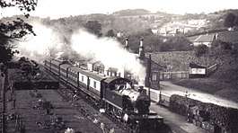 Lustleigh station in 1912 with a train for Moretonhampstead | |
| Location | |
| Place | Lustleigh |
| Area | Teignbridge |
| Grid reference | SX786814 |
| Operations | |
| Post-grouping | Great Western Railway |
| Platforms | 1 |
| History | |
| 4 July 1866 | Opened[1] |
| 2 March 1959 | Closed to passengers[1] |
| 1964 | Line closed to goods traffic |
| Disused railway stations in the United Kingdom | |
|
Closed railway stations in Britain A B C D–F G H–J K–L M–O P–R S T–V W–Z | |
|
| |
| Moretonhampstead and South Devon Railway | |
|---|---|
Lustleigh station[1] was on the Moretonhampstead and South Devon Railway serving the village of Lustleigh, Devon, England.
Lustleigh was the penultimate station on this 12.3 mile (20 km) branchline off the South Devon Main Line. It had a single platform and one siding.[2] The platform survives and the station building has been greatly enlarged.
The Moretonhampstead and South Devon Railway company was formed in 1861, and work on the line commenced in 1863. The line opened to the public in 1866 and converted from broad gauge to standard gauge in 1892.
The station closed to passengers on 28 February 1959, with goods trains continuing until 1964. The station was used on 28 February 1931 [3] for the film The Hound of the Baskervilles, its name being temporarily changed to Baskerville.[4][5]
| Preceding station | Disused railways | Following station | ||
|---|---|---|---|---|
| Pullabrook Halt | Newton Abbot to Moretonhampstead Great Western Railway |
Moretonhampstead | ||
References
- Notes
- Sources
- Beck, Keith; Copsey, John (1990). The Great Western in South Devon. Didcot: Wild Swan Publications. ISBN 0-906867-90-8.
- Butt, R (1995). The Directory of Railway Stations: details every public and private passenger station, halt, platform and stopping place, past and present (1st ed.). Sparkford: Patrick Stephens Ltd. ISBN 1-8526-0508-1.
- Ewan, M (1964). The Haytor Granite Tramway & Stover Canal. Newton Abbot: David & Charles.
- Jenkins, S C; Pomroy, L J (1989). The Moretonhampstead and South Devon Railway. Oxford: Oakwood Press. ISBN 0-85361-389-3.
Coordinates: 50°37′12″N 3°43′00″W / 50.6200°N 3.71674°W
| Wikimedia Commons has media related to Lustleigh railway station. |