Brimley Halt railway station
| Brimley Halt | |
|---|---|
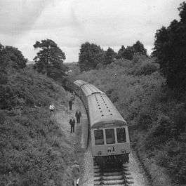 Brimley Halt with a special train in 1970 | |
| Location | |
| Place | Brimley |
| Area | Teignbridge |
| Grid reference | SX8121177562 |
| Operations | |
| Post-grouping | Great Western Railway |
| Platforms | 1 |
| History | |
| 21 May 1928[1] | Opened |
| 2 March 1959 | Closed to passengers [1] |
| 5 July 1970 | final closure |
| Disused railway stations in the United Kingdom | |
|
Closed railway stations in Britain A B C D–F G H–J K–L M–O P–R S T–V W–Z | |
|
| |
| Moretonhampstead and South Devon Railway | |
|---|---|
Brimley Halt was a railway station open in 1928 by the Great Western Railway (GWR) to serve the village of Brimley that lies between Bovey Tracey and Ilsington in South Devon, England. It had a single platform and was located on a curved section of track without a passing loop or sidings. A special train to Bovey Tracey visited Brimley Halt on 5 July 1970,[2] its last known use by a passenger train. The track had been lifted by 8 September 1975.[3]
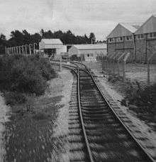
Gulf Oil Depot near Brimley Halt.
The site of the station was destroyed by the construction of a new A382 road along the course of the trackbed.[4]
| Preceding station | Disused railways | Following station | ||
|---|---|---|---|---|
| Heathfield | Newton Abbot to Moretonhampstead Great Western Railway |
Bovey | ||
References
- Notes
- 1 2 Butt, Page 44
- ↑ http://www.sixbellsjunction.co.uk/
- ↑ Kingdom, Page 318
- ↑ The site of Brimley Halt Retrieved : 2012-09-03
- Sources
- Butt, R. V. J. (1995). The Directory of Railway Stations: details every public and private passenger station, halt, platform and stopping place, past and present (1st ed.). Sparkford: Patrick Stephens Ltd. ISBN 1-8526-0508-1. OCLC 60251199.
- Kingdom, Anthony. R.; Lang, Mike (2004). The Newton Abbot to Moretonhampstead Railway. Liverton, Newton Abbot: Forest Publishing. ISBN 1-873029-09-8.
Coordinates: 50°35′08″N 3°40′45″W / 50.5856°N 3.6793°W
This article is issued from
Wikipedia.
The text is licensed under Creative Commons - Attribution - Sharealike.
Additional terms may apply for the media files.