Lumezzane
| Lumezzane Lömedhane | |
|---|---|
| Comune | |
| Comune di Lumezzane | |
 | |
 Lumezzane Location of Lumezzane in Italy | |
| Coordinates: 45°39′N 10°16′E / 45.650°N 10.267°ECoordinates: 45°39′N 10°16′E / 45.650°N 10.267°E | |
| Country | Italy |
| Region | Lombardy |
| Province | Brescia (BS) |
| Frazioni | Faidana, Fontana, Gazzolo, Gombaiolo, Mezzaluna, Montagnone, Mosniga, Piatucco, Pieve, Premiano, Renzo, San Sebastiano, Sant'Apollonio, Termine, Tufi, Valle, Villaggio Gnutti, Villaggio Gobbi |
| Government | |
| • Mayor | Matteo Zani |
| Area | |
| • Total | 31 km2 (12 sq mi) |
| Elevation | 420 m (1,380 ft) |
| Population (30 November 2017)[1] | |
| • Total | 22,255 |
| • Density | 720/km2 (1,900/sq mi) |
| Demonym(s) | Lumezzanesi |
| Time zone | UTC+1 (CET) |
| • Summer (DST) | UTC+2 (CEST) |
| Postal code | 25065 |
| Dialing code | 030 |
| Website | Official website |
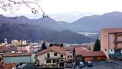
Lumezzane (Brescian: Lœmesane; locally Lömedhane [lømeˈðane]) is a town and comune in the province of Brescia, in Lombardy. With a population of 22,255 (As of 2017) it is one of the largest towns in the province of Brescia. It is situated in the Gobbia Valley, which is a side valley of the Trompia Valley.
References
- ↑ ISTAT Archived 2016-03-03 at the Wayback Machine.
External links

This article is issued from
Wikipedia.
The text is licensed under Creative Commons - Attribution - Sharealike.
Additional terms may apply for the media files.