Lulusar
| Lulusar لالو سر | |
|---|---|
 Lulusar Lake | |
| Location | Kaghan Valley, Khyber-Pakhtunkhwa |
| Coordinates | 35°0′8.04″N 73°9′2.66″E / 35.0022333°N 73.1507389°E |
| Lake type | Alpine/Glacial lake |
| Primary inflows | Glaciers water |
| Basin countries |
Indus Pakistan |
| Surface elevation | 3,410 m (11,190 ft) [1] |
| Settlements | Kaghan Valley, Naran, Balakot |
Lulusar (Urdu: لالو سر) is group of mountain peaks and a lake in the Kaghan Valley in the Khyber-Pakhtunkhwa province of Pakistan. The highest peak has a height of 11,200 ft (3,410 m) above sea level (N35.0804 E73.9266).
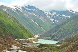
Lulusar Lake
Lulusar Lake also known as Lulusir is a lake at 3,410 m (11,190 ft), is the primary headwaters of the Kunhar River.[1] It flows southwest through the entire length of Kaghan Valley passing Jalkhand, Naran, Kaghan, Jared, Paras and Balakot until its confluence with the Jhelum River. It is located about 48 kilometres (30 mi) away from Naran and is accessible by any kind of vehicle.[2]
See also
| Wikimedia Commons has media related to Lulusar Lake. |
- Lulusar-Dudipatsar National Park
- Lake Saiful Muluk - Kaghan Valley
- Dudipatsar Lake - Kaghan Valley
- Ansoo Lake - Kaghan Valley
- Mahodand Lake - Kalam Valley
- Kundol Lake - Kalam Valley
- Daral Lake - Swat Valley
- List of lakes in Pakistan
References
- 1 2 "Lulusar Lake". Tourism Development Corporation of Punjab (TDCP). Archived from the original on 7 January 2009. Retrieved 9 January 2009.
- ↑ "Lulusar (also known as Lulusir) Lake - Distance from Naran". Ajktours.com. Retrieved 12 August 2018.
This article is issued from
Wikipedia.
The text is licensed under Creative Commons - Attribution - Sharealike.
Additional terms may apply for the media files.