Luha River
| Luha / Lug | |
|---|---|
 | |
| Country |
|
| Physical characteristics | |
| Main source | village Kolpytiv, Lokachi Raion |
| River mouth |
Bug River 50°52′02″N 24°08′44″E / 50.86722°N 24.14556°ECoordinates: 50°52′02″N 24°08′44″E / 50.86722°N 24.14556°E |
| Length | 93 km (58 mi) |
| Basin features | |
| Progression | Bug→ Narew→ Vistula→ Baltic Sea |
| Basin size | 1,348 km2 (520 sq mi) |
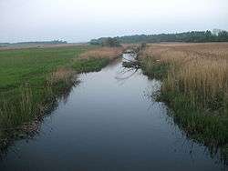
The Luha (Ukrainian: Луга, Polish: Ług) is a river in Ukraine and a right tributary of the Bug River. Its source is located near village Kolpytiv located at the Horokhiv Upland and in its upper reaches the Luha runs mainly in western, northwestern direction, later in northward. In its lower stream it runs mainly in northwestern direction and enters Western Bug on northwestern outskirts of the city of Ustyluh.
Biggest tributaries: Luha-Svynoryika, Svynoryika, Rylovytsia (right side); Strypa (left side)
Character of the river is plain as it flows through swampy floodplains.
Major settlements along the river: Volodymyr-Volynskyi, Ustyluh
In 2000 along the river was created local hydrological reserve "Luha".[1]
References
External links
- Luha at the OpenStreetMap
This article is issued from
Wikipedia.
The text is licensed under Creative Commons - Attribution - Sharealike.
Additional terms may apply for the media files.