List of state highways in Louisiana
| Louisiana State Highways | |
|---|---|
.svg.png)  .svg.png) State highway markers for different years: 1955 (left), 1990 (center), 2008–present (right) | |
| System information | |
| Length | 16,698.41 mi[1] (26,873.49 km) |
| Formed | 1955 renumbering[2] |
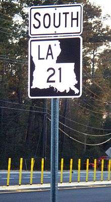
| Notes | Since 2008, La DOTD has been replacing the green-and-white state highway markers with a black-and-white version using the same design. The new shields have a black background, white silhouette, black letters and numbers, and no frame outline (see photo below for comparison). |
| Highway names | |
| State | Louisiana Highway X (LA X) |
| Special routes: |
Louisiana Highway X Alternate (LA X Alt.); Louisiana Highway X Business (LA X Bus.); Louisiana Highway X Bypass (LA X Byp.); Louisiana Highway X Spur (LA X Spur); Louisiana Highway X Truck (LA X Truck) |
| System links | |
| |

Pre-1955 state highway system
Current state highways
LA 1 to LA 191
LA 300 to LA 1266
|
|
|
|
|
|
|
LA 3000 to LA 3282
|
|
|
|
|
|
|
|
|
|
Former state highways
Note: Year of deletion appears in parentheses.
|
|
|
|
|
Proposed state highways
- LA 3145: unbuilt Ivanhoe–Jeanerette highway (1970s)
- LA 3241: I-12–Bush highway (1980s–present) – survey contracts awarded
See also


References
Footnotes
- ↑ "La DOTD GIS". Louisiana Department of Transportation and Development. 2013. Archived from the original on October 16, 2013. Retrieved October 19, 2013.
- ↑ "Act No. 40, House Bill No. 311". State-Times. Baton Rouge. June 18, 1955. pp. 3B–7B.
Works cited
- Louisiana Department of Transportation and Development, Highway Inventory Unit (2016). "LRS Conversion Tool". Louisiana Department of Transportation and Development. Retrieved February 7, 2018.
External links
- Maps / GIS Data Homepage, Louisiana Department of Transportation and Development
| Highway systems | |
|---|---|
| Highway agency | |
This article is issued from
Wikipedia.
The text is licensed under Creative Commons - Attribution - Sharealike.
Additional terms may apply for the media files.