Louisiana Highway 819
| ||||
|---|---|---|---|---|
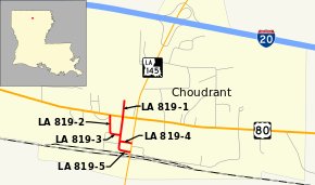 Routes of all LA 819 segments highlighted in red | ||||
| Route information | ||||
| Maintained by Louisiana DOTD | ||||
| Length | 0.583 mi[1] (0.938 km) | |||
| Existed | 1955 renumbering – present | |||
| Location | ||||
| Parishes | Lincoln | |||
| Highway system | ||||
| ||||
.svg.png)
Louisiana Highway 819 (LA 819) is a collection of five state-maintained streets located in the Lincoln Parish village of Choudrant that have a total length of 0.58 miles (0.93 km).[1] All five routes were established in the 1955 Louisiana Highway renumbering[2] and are presently unsigned.
Louisiana Highway 819-1
| |
|---|---|
| Location | Choudrant |
| Length | 0.272 mi[1] (0.438 km) |
| Existed | 1955–present |
Louisiana Highway 819-1 (LA 819-1) runs 0.27 miles (0.43 km) in a north–south direction along Oak Street from LA 819-5 (North Depot Street) to a dead end north of US 80.[3] It is an undivided two-lane highway for its entire length.
The entire highway is in Choudrant, Lincoln Parish.
| mi[1] | km | Destinations | Notes | ||
|---|---|---|---|---|---|
| 0.000 | 0.000 | Southern terminus of LA 819-1; western terminus of LA 819-5 | |||
| 0.051 | 0.082 | Western terminus of LA 819-4 | |||
| 0.083 | 0.134 | Eastern terminus of LA 819-3 | |||
| 0.197 | 0.317 | ||||
| 0.272 | 0.438 | End state maintenance at dead end | Northern terminus | ||
| 1.000 mi = 1.609 km; 1.000 km = 0.621 mi | |||||
Louisiana Highway 819-2
| |
|---|---|
| Location | Choudrant |
| Length | 0.108 mi[1] (0.174 km) |
| Existed | 1955–present |
Louisiana Highway 819-2 (LA 819-2) runs 0.11 miles (0.18 km) in a north–south direction along Pecan Street from LA 819-3 (Green Street) to US 80.[4] The route travels alongside Choudrant High School and is an undivided two-lane highway for its entire length.
The entire highway is in Choudrant, Lincoln Parish.
| mi[1] | km | Destinations | Notes | ||
|---|---|---|---|---|---|
| 0.000 | 0.000 | Southern terminus of LA 819-2; western terminus of LA 819-3 | |||
| 0.108 | 0.174 | Northern terminus | |||
| 1.000 mi = 1.609 km; 1.000 km = 0.621 mi | |||||
Louisiana Highway 819-3
| |
|---|---|
| Location | Choudrant |
| Length | 0.064 mi[1] (0.103 km) |
| Existed | 1955–present |
Louisiana Highway 819-3 (LA 819-3) runs 0.06 miles (0.097 km) in an east–west direction along Green Street from LA 819-2 (Pecan Street) to LA 819-1 (Oak Street).[5] It is an undivided two-lane highway for its entire length.
The entire highway is in Choudrant, Lincoln Parish.
| mi[1] | km | Destinations | Notes | ||
|---|---|---|---|---|---|
| 0.000 | 0.000 | Western terminus of LA 819-3; southern terminus of LA 819-2 | |||
| 0.064 | 0.103 | Eastern terminus | |||
| 1.000 mi = 1.609 km; 1.000 km = 0.621 mi | |||||
Louisiana Highway 819-4
| |
|---|---|
| Location | Choudrant |
| Length | 0.072 mi[1] (0.116 km) |
| Existed | 1955–present |
Louisiana Highway 819-4 (LA 819-4) runs 0.07 miles (0.11 km) in an east–west direction along Allen Street from LA 819-1 (Oak Street) to LA 145 (Elm Street).[6] It is an undivided two-lane highway for its entire length.
The entire highway is in Choudrant, Lincoln Parish.
| mi[1] | km | Destinations | Notes | ||
|---|---|---|---|---|---|
| 0.000 | 0.000 | Western terminus | |||
| 0.072 | 0.116 | Eastern terminus | |||
| 1.000 mi = 1.609 km; 1.000 km = 0.621 mi | |||||
Louisiana Highway 819-5
| |
|---|---|
| Location | Choudrant |
| Length | 0.067 mi[1] (0.108 km) |
| Existed | 1955–present |
Louisiana Highway 819-5 (LA 819-5) runs 0.07 miles (0.11 km) in an east–west direction along North Depot Street from LA 819-1 (Oak Street) to LA 145 (Elm Street).[7] It is an undivided two-lane highway for its entire length.
The entire highway is in Choudrant, Lincoln Parish.
| mi[1] | km | Destinations | Notes | ||
|---|---|---|---|---|---|
| 0.000 | 0.000 | Western terminus of LA 819-5; southern terminus of LA 819-1 | |||
| 0.067 | 0.108 | Eastern terminus | |||
| 1.000 mi = 1.609 km; 1.000 km = 0.621 mi | |||||
See also


References
- 1 2 3 4 5 6 7 8 9 10 11 12 "La DOTD GIS Data". Louisiana Department of Transportation and Development. September 2015. Retrieved November 10, 2015.
- ↑ "Act No. 40, House Bill No. 311". State-Times. Baton Rouge. June 18, 1955. p. 5B.
- ↑ Google (December 28, 2015). "Overview Map of LA 819-1" (Map). Google Maps. Google. Retrieved December 28, 2015.
- ↑ Google (December 28, 2015). "Overview Map of LA 819-2" (Map). Google Maps. Google. Retrieved December 28, 2015.
- ↑ Google (December 28, 2015). "Overview Map of LA 819-3" (Map). Google Maps. Google. Retrieved December 28, 2015.
- ↑ Google (December 28, 2015). "Overview Map of LA 819-4" (Map). Google Maps. Google. Retrieved December 28, 2015.
- ↑ Google (December 28, 2015). "Overview Map of LA 819-5" (Map). Google Maps. Google. Retrieved December 28, 2015.
External links
Route map: