Louina, Alabama
| Louina | |
|---|---|
| Unincorporated community | |
 | |
 Louina Location in Alabama. | |
| Coordinates: 33°07′28″N 85°33′08″W / 33.12444°N 85.55222°WCoordinates: 33°07′28″N 85°33′08″W / 33.12444°N 85.55222°W | |
| Country | United States |
| State | Alabama |
| County | Randolph |
| Elevation | 682 ft (208 m) |
| Time zone | UTC-6 (Central (CST)) |
| • Summer (DST) | UTC-5 (CDT) |
| Area code(s) | 334 |
| GNIS feature ID | 156631[1] |
Louina, sometimes Ole Louina, is a ghost town located 14 miles west of Roanoke and about one mile east of Wadley in Randolph County, Alabama, United States.
History
Ole Louina was a community during early settlement of Randolph County which was settled after the Battle of Horseshoe Bend in 1814 when the Creek Indians were defeated by General Andrew Jackson.
The town was founded in 1834 and lasted until about 1905, and at one time was largest town in Randolph County with two churches, several stores, and a gristmill.
Demographics
| Historical population | |||
|---|---|---|---|
| Census | Pop. | %± | |
| 1880 | 148 | — | |
| U.S. Decennial Census[2] | |||
Louina appeared on the 1880 U.S. Census with a population of 148 residents. It was the only time it appeared on census rolls.
Notable person
- James Thomas Heflin, a leading proponent of white supremacy who served as a Democratic Congressman and United States Senator
Gallery
 The "Liberty West Baptist Cemetery" is one of the last remaining vestiges of Louina, Alabama.
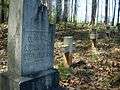


External links
References
- ↑ "Louina". Geographic Names Information System. United States Geological Survey.
- ↑ "U.S. Decennial Census". Census.gov. Retrieved June 6, 2013.
Municipalities and communities of Randolph County, Alabama, United States | ||
|---|---|---|
| City | 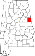 | |
| Towns | ||
| CDPs | ||
| Unincorporated communities | ||
This article is issued from
Wikipedia.
The text is licensed under Creative Commons - Attribution - Sharealike.
Additional terms may apply for the media files.