Lough Dan
| Lough Dan Loch Deán | |
|---|---|
.jpg) | |
| Location | County Wicklow |
| Coordinates | 53°04′32″N 6°17′09″W / 53.075436°N 6.285918°WCoordinates: 53°04′32″N 6°17′09″W / 53.075436°N 6.285918°W |
| Primary inflows | River Cloghoge, River Inchavore |
| Primary outflows | River Avonmore |
| Basin countries | Ireland |
| Max. length | 3 km (1.9 mi) |
| Max. width | 0.5 km (0.31 mi) |
| Surface area | 106 ha (260 acres) |
| Average depth | 13.5 m (44 ft) |
| Surface elevation | 205 m (673 ft) |
| Islands | 0 |
Lough Dan (Irish: Loch Deán) is a boomerang-shaped ribbon lake near Roundwood, County Wicklow, Ireland. It is a popular area for hikers and kayakers and lies very close to the Wicklow Way.
The Inchavore river flows into Lough Dan from the north-west. An outflow from Lough Tay - the Cloghoge river - feeds it via from the north-east. It is drained to the south by the River Avonmore. Most of the lake is surrounded by private lands, though the north-western corner is part of the Wicklow National Park.
| “ | The Cloghoge River flows out of Lough Tay and into Lough Dan. The Inchavore River flows in another glacial valley from the west to enter Lough Dan. The scenery around here is spectacular. The valley floor at 230m is very fertile. The remains of lazy beds, which were ridges built for growing vegetables, cover the valley. They are evidence of higher population levels in the mountains in the past. Arctic Char Salvelinus alpinus was last recorded in the lake in 1988. This fish is one of the oldest inhabitants of Ireland but a recent survey found no trace of them, indicating the species is now extinct in Co. Wicklow. There are Peregrine Falcon sites on the steep cliffs overlooking the lake on the eastern side, and some lovely broad-leaved woodland in the Inchavore Valley. The Cloghoge and Inchavore Rivers are rich in invertebrates and breeding Dippers and Grey Wagtails can be seen around the river. Herons and Cormorants roost near the mouth of the Cloghoge River.[1] | ” |
Scouting
The Scouting Ireland S.A.I. national campsite, now one of several belonging to Scouting Ireland, lies beside the lake.
Scouting Jamboree
In 1997, Lough Dan was the site of an Irish Scouting jamboree, Lough Dan '97, at the S.A.I. national campsite, co-organised by the Federation of Irish Scouts Associations. The Jamboree was abandoned on the Thursday due to inclement weather and flooding.
Gallery
.jpg) Snow around Lough Dan
Snow around Lough Dan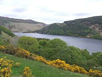 Looking north from the west bank
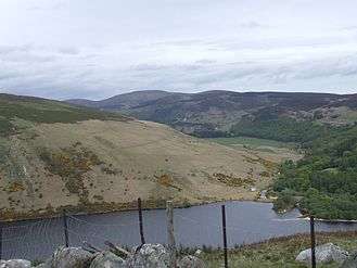 Looking south-east from the west bank
See also
References
- ↑ Wicklow Mountains National Park - Lakes and Rivers, Habitats Archived 2006-08-27 at the Wayback Machine.
External links
- Wicklow Mountains National Park page
- Irelandscape section on Lough Dan
- Mountain Views information about the Knocknacloghoge area
- Online climbing guide to Lough Dan site