Lorentz River
| The Lorentz River (Nordfluss, Unir or Undir) | |
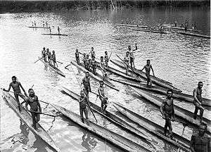 The Lorenz during the third South New Guinea expedition (1912-13) | |
| Country | |
|---|---|
| State | Province of Papua |
| Source | Southeast of the Puncak Trikora in the Jayawijaya Mountains |
| - location | New Guinea, Indonesia |
| - coordinates | 4°15′S 138°40′E / 4.250°S 138.667°E |
| Length | 3,800 km (2,361 mi) |
| Depth | 17 m (56 ft) |
The Lorentz River (also Unir or Undir) is located in the Indonesian province of Papua in Western New Guinea. It originates in the central east-west mountain range of New Guinea, and flows southwards into the Arafura Sea at Flamingo Bay. During the first two Dutch expeditions to Southern New Guinea (1907–10) it was called Northern River. In 1910 it was renamed after the Dutch explorer Hendrikus Albertus Lorentz. After it became part of Indonesia, it was renamed to Unir, as in the language of the local Asmat people, while the Lorentz name is still in use.
At the beginning of the 20th century the navigable part of the river played an important role in the exploration of Dutch New Guinea in western New Guinea. Three large Dutch expeditions led from the mouth upstream to the central snow-capped mountains, which were still unexplored. The aim of the expeditions was to cover the Wilhelmina summit (now called Puncak Trikora ) covered by "eternal snow" . The first of the three South New Guinea expeditions failed before the mountain could be reached. The second expedition reached the snow-capped foot of Wilhelmina, but it was only during the third expedition that the mountain could be conquered on 21 February 1913.
External links
- Map and pictures of Lorentz River from The Papua Insects Foundation.
Coordinates: 5°32′32″S 138°02′36″E / 5.54222°S 138.04333°E