Conroe-North Houston Regional Airport
| Conroe-North Houston Regional Airport | |||||||||||||||
|---|---|---|---|---|---|---|---|---|---|---|---|---|---|---|---|
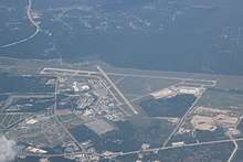 Aerial view of the airport looking northeastwards | |||||||||||||||
| Summary | |||||||||||||||
| Airport type | Public | ||||||||||||||
| Owner | Montgomery County | ||||||||||||||
| Serves | Houston, Texas | ||||||||||||||
| Location | Conroe, Texas | ||||||||||||||
| Elevation AMSL | 245 ft / 75 m | ||||||||||||||
| Coordinates | 30°21′09″N 095°24′52″W / 30.35250°N 95.41444°WCoordinates: 30°21′09″N 095°24′52″W / 30.35250°N 95.41444°W | ||||||||||||||
| Website |
www | ||||||||||||||
| Map | |||||||||||||||
 CXO Location of airport in Texas / United States  CXO CXO (the US) | |||||||||||||||
| Runways | |||||||||||||||
| |||||||||||||||
| Statistics (2006) | |||||||||||||||
| |||||||||||||||
Conroe-North Houston Regional Airport (IATA: CXO, ICAO: KCXO, FAA LID: CXO) (formerly known as Lone Star Executive Airport and Montgomery County Airport) is a public-use airport in Conroe, Texas, United States,[1] 37 miles (60 km) north of the central business district of Houston.[2] It is publicly-owned by Montgomery County.
History
Conroe-North Houston Regional Airport was constructed during World War II to serve as a military facility, but was converted in 1945 to be a predominately civilian airfield.[3]
Facilities
Conroe-North Houston Regional Airport covers an area of 1,277 acres (517 ha) which contains two concrete runways: 14/32 with dimensions of 7,501 x 150 ft (1,829 x 46 m); and 1/19 of 5,000 x 100 ft (1,524 x 30 m).[2]
For the 12-month period ending April 30, 2010, the airport had 78,432 aircraft operations, an average of 215 per day: 94% general aviation, 5% military and <1% air taxi. At that time there were 254 aircraft based at this airport: 74% single-engine, 15% multi-engine, 3% jet, 3% helicopter and 5% military.[2]
There are currently two fixed-base operators at the airport.
The United States Army maintains a base at the airport, called the Conroe United States Army Reserve Center. The 1st Battalion, 158th Aviation Regiment is stationed at the base.
Accidents and incidents
- On June 20, 1996, Douglas DC-3A N23WT of Loren Davis Ministries International was destroyed in a crash at Cut and Shoot, Texas. The aircraft was on a training flight based at Conroe Airport when an engine failure occurred. The co-pilot did not hear the call to feather the propellor on the affected engine. The aircraft flew into a tree, hit power lines and was destroyed in the subsequent fire.[4] A witness stated that the aircraft was lifted off with insufficient airspeed. The crew also attempted to fly the aircraft at an incorrect airspeed following the engine failure.[5]
- On September 19, 2014, a NetJets-operated Embraer Phenom 300 arriving from Nashville International Airport slid off the runway.[6] The area had recently been inundated by the remains of Hurricane Odile. Neither the pilot nor co-pilot were hurt.
References
- 1 2 Lone Star Executive Airport Archived 2008-03-23 at the Wayback Machine. at Montgomery County web site
- 1 2 3 4 FAA Airport Master Record for CXO (Form 5010 PDF), effective 2007-12-20
- ↑ Jackson, Charles Christopher. "Conroe, Texas". Handbook of Texas Online. Retrieved 2008-03-03.
- ↑ "N23WT Accident description". Aviation Safety Network. Retrieved 25 June 2010.
- ↑ "FTW96FA262". National Transportation Safety Board. Retrieved 29 June 2010.
- ↑ "Plane slides off runway at regional airport in Conroe". KPRC-TV. Retrieved 19 September 2014.
External links
- Resources for this airport:
- FAA airport information for CXO
- AirNav airport information for KCXO
- ASN accident history for CXO
- FlightAware airport information and live flight tracker
- NOAA/NWS latest weather observations
- SkyVector aeronautical chart, Terminal Procedures