Lone Oak Township, Bates County, Missouri
| Lone Oak Township | |
|---|---|
| Township | |
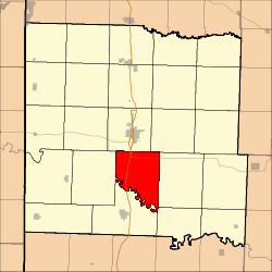 Location in Bates County | |
| Coordinates: 38°10′20″N 94°18′40″W / 38.17222°N 94.31111°WCoordinates: 38°10′20″N 94°18′40″W / 38.17222°N 94.31111°W | |
| Country |
|
| State |
|
| County | Bates |
| Area | |
| • Total | 35.96 sq mi (93.15 km2) |
| • Land | 35.94 sq mi (93.08 km2) |
| • Water | 0.03 sq mi (0.07 km2) 0.08% |
| Elevation | 817 ft (249 m) |
| Population (2000) | |
| • Total | 293 |
| • Density | 8.2/sq mi (3.1/km2) |
| Time zone | UTC-6 (CST) |
| • Summer (DST) | UTC-5 (CDT) |
| ZIP codes | 64730, 64779 |
| GNIS feature ID | 0766298 |
Lone Oak Township is one of twenty-four townships in Bates County, Missouri, USA. As of the 2000 census, its population was 293.[1]
The township takes its name from Lone Oak Branch creek.[2]
Geography
According to the United States Census Bureau, Lone Oak Township covers an area of 35.96 square miles (93.15 square kilometers); of this, 35.94 square miles (93.08 square kilometers, 99.92 percent) is land and 0.03 square miles (0.07 square kilometers, 0.08 percent) is water.
Unincorporated towns
- Athol at 38°10′21″N 94°22′44″W / 38.172527°N 94.37884°W
- Monteith Junction at 38°12′51″N 94°22′01″W / 38.214192°N 94.366896°W
- Peru at 38°10′57″N 94°17′31″W / 38.182527°N 94.291894°W
(This list is based on USGS data and may include former settlements.)
Adjacent townships
- Mount Pleasant Township (north)
- Summit Township (northeast)
- Pleasant Gap Township (east)
- Prairie Township (southeast)
- Osage Township (southwest)
- New Home Township (west)
Cemeteries
The township contains Fairview Cemetery.
Major highways
School districts
- Butler R-V School District
- Rich Hill R-IV
Political districts
- Missouri's 4th congressional district
- State House District 125
- State Senate District 31
References
- United States Census Bureau 2008 TIGER/Line Shapefiles
- United States Board on Geographic Names (GNIS)
- United States National Atlas
- ↑ United States Census Bureau American FactFinder
- ↑ "Bates County Place Names, 1928-1945 (archived)". The State Historical Society of Missouri. Archived from the original on 24 June 2016. Retrieved 1 September 2016.
External links
Places adjacent to Lone Oak Township, Bates County, Missouri | |
|---|---|
Municipalities and communities of Bates County, Missouri, United States | ||
|---|---|---|
| Cities | 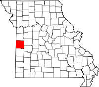 | |
| Villages | ||
| Townships | ||
| Unincorporated communities | ||
| Ghost towns | ||
| Footnotes | ‡This populated place also has portions in an adjacent county or counties | |
This article is issued from
Wikipedia.
The text is licensed under Creative Commons - Attribution - Sharealike.
Additional terms may apply for the media files.