Roman road from Silchester to Bath
The route from Londinium (London) to Aquae Sulis (Bath) comprised the road from Aquae Sulis to Calleva (Silchester), and then the Devil's Highway connecting Calleva to Londinium.
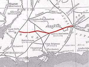
The Roman road from Silchester to Bath connected Calleva Atrebatum (Silchester) with Aquae Sulis (Bath) via Spinae (Speen), Cunetio and Verlucio (near Sandy Lane).[1][2] Portions of the original road are extant, while in other places all apparent vestiges are absent from view. The road was a significant route for east-west travel and military logistics in southeast England during the 1st to 5th centuries. During the Middle Ages, the road was used by drovers, as well as by merchants and travelers.
See also
References
- ↑ Wansdyke Project description of the Roman road from London to Bath
- ↑ Linford, N T; Linford, P K; Payne, A W (February 2018). "Verlucio and Environs Project, Bowood Estate, Calne Without, Wiltshire: Report on Geophysical Surveys". Historic England. Retrieved 5 August 2018.
Coordinates: 51°21′31″N 1°01′54″W / 51.35857°N 1.03177°W
This article is issued from
Wikipedia.
The text is licensed under Creative Commons - Attribution - Sharealike.
Additional terms may apply for the media files.