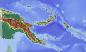
Loloru
| Loloru | |
|---|---|
 Loloru | |
| Highest point | |
| Elevation | 1,887 m (6,191 ft) |
| Coordinates | 6°31′S 155°37′E / 6.517°S 155.617°E |
| Geography | |
| Location | Bougainville, Papua New Guinea |
| Geology | |
| Mountain type | Pyroclastic shield |
| Last eruption | 1050 BCE (?) |
Loloru is a pyroclastic shield volcano located in the southern region of Bougainville Island, within the Autonomous Region of Bougainville of northeastern Papua New Guinea.
The volcano's summit consists of two nested calderas, with an andesitic lava dome.
Lake Loloru

Traditionally sacred Lake Loloru, a crater lake.
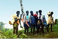
Boys from Buin and Siwai visiting Lake Loloru (1978).
Lake Loloru, a crescent-shaped crater lake, is within the volcano. It is a sacred place of South Bougainvillians, who traditionally believe the souls of their dead go here upon death.
See also
- Volcanoes of Bougainville Island
- List of volcanoes in Papua New Guinea
References
This article is issued from
Wikipedia.
The text is licensed under Creative Commons - Attribution - Sharealike.
Additional terms may apply for the media files.