Lofthus, Hordaland
| Lofthus | |
|---|---|
| Village | |
 View of the village | |
 Lofthus Location in Hordaland county  Lofthus Lofthus (Norway) | |
| Coordinates: 60°19′57″N 06°39′42″E / 60.33250°N 6.66167°ECoordinates: 60°19′57″N 06°39′42″E / 60.33250°N 6.66167°E | |
| Country | Norway |
| Region | Western Norway |
| County | Hordaland |
| District | Hardanger |
| Municipality | Ullensvang |
| Area[1] | |
| • Total | 0.67 km2 (0.26 sq mi) |
| Elevation[2] | 100 m (300 ft) |
| Population (2013)[1] | |
| • Total | 556 |
| • Density | 830/km2 (2,100/sq mi) |
| Time zone | UTC+01:00 (CET) |
| • Summer (DST) | UTC+02:00 (CEST) |
| Post Code | 5781 Lofthus |
Lofthus is a village in the municipality of Ullensvang, which is located in the Hardanger region of Hordaland county, Norway. The village lies along the eastern shore of the Sørfjorden, along Norwegian National Road 13. Lofthus is located about 10 kilometres (6.2 mi) south of the village of Kinsarvik and about 30 kilometres (19 mi) north of the town of Odda. The 0.67-square-kilometre (170-acre) village of Lofthus has a population (2013) of 556, giving the village a population density of 830 inhabitants per square kilometre (2,100/sq mi).[1]
Lofthus is a tourist area with hotels and camping sites. There is also a significant amount of fruit farming in the area, and so Lofthus is home to a national fruit research centre. The most popular fruit grown in this area is the cherry. The medieval Ullensvang Church is located in this village, as is the Hardanger folk high school.[3]
Notable people
Notable people that were born or lived in Lofthus include:
- Halldor O. Opedal (1895–1986), folkorist
Media gallery
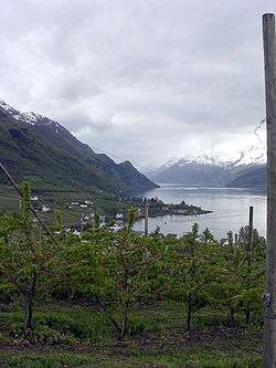 View of Lofthus
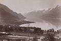 Old picture of Lofthus
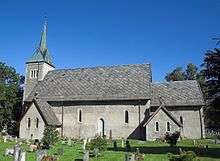 The medieval Ullensvang Church
References
- 1 2 3 Statistisk sentralbyrå (1 January 2013). "Urban settlements. Population and area, by municipality".
- ↑ "Lofthus, Ullensvang" (in Norwegian). yr.no. Retrieved 2014-06-03.
- ↑ Store norske leksikon. "Lofthus" (in Norwegian). Retrieved 2014-06-03.