Lockney, West Virginia
| Lockney, West Virginia | |
|---|---|
| Unincorporated community | |
 Lockney  Lockney | |
| Coordinates: 38°51′22″N 80°58′01″W / 38.85611°N 80.96694°WCoordinates: 38°51′22″N 80°58′01″W / 38.85611°N 80.96694°W | |
| Country | United States |
| State | West Virginia |
| County | Gilmer |
| Elevation | 718 ft (219 m) |
| Time zone | UTC-5 (Eastern (EST)) |
| • Summer (DST) | UTC-4 (EDT) |
| Area code(s) | 304 & 681 |
| GNIS feature ID | 1542288[1] |
Lockney is an unincorporated community in Gilmer County, West Virginia, United States. Lockney is located along U.S. Routes 33 and 119 and the Left Fork Steer Creek 9 miles (14 km) southwest of Glenville.[2] Lockney had a post office, which opened on May 17, 1898, and closed on November 9, 2002.[3] The community was named after H. C. Lockney, a senator who was instrumental in securing for the town a post office.[4]
References
- ↑ U.S. Geological Survey Geographic Names Information System: Lockney, West Virginia
- ↑ Gilmer County, West Virginia General Highway Map (PDF) (Map). West Virginia Department of Transportation. 2011. p. 2. Archived from the original (PDF) on April 25, 2012. Retrieved October 12, 2011.
- ↑ "Postmaster Finder - Post Offices by ZIP Code". United States Postal Service. Retrieved October 12, 2011.
- ↑ Kenny, Hamill (1945). West Virginia Place Names: Their Origin and Meaning, Including the Nomenclature of the Streams and Mountains. Piedmont, WV: The Place Name Press. p. 380.
Municipalities and communities of Gilmer County, West Virginia, United States | ||
|---|---|---|
| Towns | 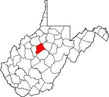 | |
| Unincorporated communities | ||
| Footnotes | ‡This populated place also has portions in an adjacent county or counties | |
This article is issued from
Wikipedia.
The text is licensed under Creative Commons - Attribution - Sharealike.
Additional terms may apply for the media files.