Lock and Dam No. 10
| Lock and Dam No. 10 | |
|---|---|
 Mississippi River Lock and Dam number 10 | |
 Location of Lock and Dam No. 10 in Iowa | |
| Location | Guttenberg, Clayton County, Iowa / Glen Haven, Grant County, Wisconsin, USA |
| Coordinates | 42°47′06″N 91°05′42″W / 42.78500°N 91.09500°WCoordinates: 42°47′06″N 91°05′42″W / 42.78500°N 91.09500°W |
| Construction began | 1934 |
| Opening date | November 1937 |
| Operator(s) | U.S. Army Corps of Engineers, St. Paul District |
| Dam and spillways | |
| Impounds | Upper Mississippi River |
| Length | 5,447 feet (1,660.2 m) |
| Reservoir | |
| Creates | Pool 10 |
| Total capacity | 212,000 acre⋅ft (0.261 km3) |
| Catchment area | 79,370 sq mi (205,600 km2) |
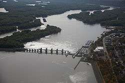
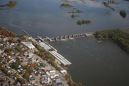
Lock and Dam No. 10 is a lock and dam located in Guttenberg, Iowa on the Upper Mississippi River around river mile 615.0. It was constructed and placed in operation November 1937. The site underwent major rehabilitation 1989—2006. The dam consists of a concrete dam 763 feet (232.6 m) long with four roller gates and eight tainter gates. The earth embankment is 4,223 feet (1,287.2 m) long[1] with a concrete spillway 1,200 feet (365.8 m) long. The lock is 110 feet (33.5 m) wide by 600 feet (182.9 m) long. The lock and dam are owned and operated by the St. Paul District of the United States Army Corps of Engineers-Mississippi Valley Division.
The Friends of Pool 10 is a volunteer organization dedicated to the cleanup of the sloughs, backwaters and islands of the pool. Its first annual cleanup was in April 2007.
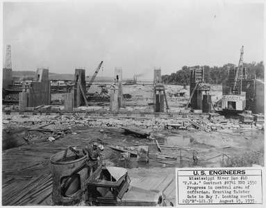 Public Works Administration Project, Army Corps of Engineers, Dam.
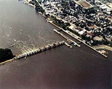
See also
References
External links
- U.S. Army Corps of Engineers, St. Paul District: Lock and Dam 10
- U.S. Army Corps of Engineers, St. Paul District: Lock and Dam 10 brochure
- USGS Reach 1, Pool 10
- Civil works Digital project notebook
- Survey number HAER IA-22 - Upper Mississippi River 9-Foot Channel, Lock & Dam No. 10, Guttenberg, Clayton County, IA
| Locks and dams of the Upper Mississippi River | ||
|---|---|---|
| Upstream: Lock and Dam No. 9 |
Downstream: Lock and Dam No. 11 | |