Loch Anna
| Loch Anna | |
|---|---|
 | |
| Location | Lochalsh, Scotland |
| Coordinates | 57°18′14″N 5°31′27″W / 57.304000°N 5.524300°WCoordinates: 57°18′14″N 5°31′27″W / 57.304000°N 5.524300°W[1] |
| Type | freshwater loch |
| Primary inflows | Allt Loch Anna [2] |
| Basin countries | Scotland |
| Max. length | 0.5 km (0.31 mi)[2] |
| Surface area | 9.9 ha (24 acres)[1] |
| Average depth | 4 m (13 ft)[2] |
| Max. depth | 8.2 m (27 ft)[2] |
| Water volume | 13,000,000 cu ft (370,000 m3)[2] |
| Shore length1 | 1.8 km (1.1 mi)[1] |
| Surface elevation | 317 m (1,040 ft)[1] |
| Islands | 1[1] |
| 1 Shore length is not a well-defined measure. | |
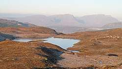
Loch Anna is a small, upland, freshwater loch approximately 2.4 km (1.5 mi) north of Loch Alsh at Ardelve, in Lochalsh, Scotland. It lies in a northwest to southeast direction, is approximately 0.5 km (0.31 mi) in length, and is at an altitude of 317 m (1,040 ft).[1][2] The loch is irregular in shape, is on average 4 m (13 ft) deep, with a maximum depth of 8.2 m (27 ft). It was surveyed in 1904 by James Murray[3] as part of Sir John Murray's Bathymetrical Survey of Fresh-Water Lochs of Scotland 1897-1909.
References
- 1 2 3 4 5 6 "Loch Anna". British lakes. British Lakes. Retrieved 10 September 2017.
- 1 2 3 4 5 6 "Bathymetrical Survey of the Fresh-Water Lochs of Scotland, 1897-1909, Lochs of Alsh Basin". National Library of Scotland. Retrieved 10 September 2017.
- ↑ "Loch Anna; Loch na Leitreach (Vol. 5, Plate 23)". National Library of Scotland. Retrieved 10 September 2017.
This article is issued from
Wikipedia.
The text is licensed under Creative Commons - Attribution - Sharealike.
Additional terms may apply for the media files.