Lloydminster Airport
| Lloydminster Airport | |||||||||||||||
|---|---|---|---|---|---|---|---|---|---|---|---|---|---|---|---|
 Lloydminster Airport | |||||||||||||||
| Summary | |||||||||||||||
| Airport type | Public | ||||||||||||||
| Operator | City of Lloydminster | ||||||||||||||
| Serves | Lloydminster, Alberta | ||||||||||||||
| Time zone | MST (UTC−07:00) | ||||||||||||||
| • Summer (DST) | MDT (UTC−06:00) | ||||||||||||||
| Elevation AMSL | 2,194 ft / 669 m | ||||||||||||||
| Coordinates | 53°18′38″N 110°04′27″W / 53.31056°N 110.07417°WCoordinates: 53°18′38″N 110°04′27″W / 53.31056°N 110.07417°W | ||||||||||||||
| Website | www.lloydminster.ca/airport.html | ||||||||||||||
| Map | |||||||||||||||
 CYLL Location in Alberta | |||||||||||||||
| Runways | |||||||||||||||
| |||||||||||||||
| Statistics (2012) | |||||||||||||||
| |||||||||||||||
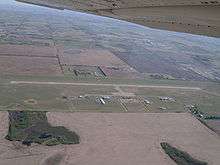
Lloydminster Airport, (IATA: YLL, ICAO: CYLL), is located 2 nautical miles (3.7 km; 2.3 mi) northwest of Lloydminster, Alberta, Canada.
History
Built in 1981 at a cost of $6.3 million[4] to replace the previous Lloydminster Airport, the new airport serves as the largest airport in the region. Despite the City of Lloydminster's status as a border city straddling the provincial border, the airport is located entirely within Alberta, whereas the old airport was entirely within Saskatchewan. Remnants of the old airport are still visible today at 53°17′54.45″N 110°00′03.85″W / 53.2984583°N 110.0010694°W
Destinations
| Airlines | Destinations |
|---|---|
| Central Mountain Air | Calgary |
| WestJet Link | Calgary[5] |
References
- ↑ Canada Flight Supplement. Effective 0901Z 19 July 2018 to 0901Z 13 September 2018.
- ↑ Synoptic/Metstat Station Information Archived 2011-12-01 at the Wayback Machine.
- ↑ Total aircraft movements by class of operation — NAV CANADA flight service stations
- ↑ Forgotten Echoes Historical Society (1982). Forgotten echoes : a history of Blackfoot and surrounding area. Blackfoot, Alberta. p. 59.
- ↑ "WestJet Link launch delayed". WestJet. January 31, 2018. Retrieved February 1, 2018.
External links
- Past three hours METARs, SPECI and current TAFs for Lloydminster Airport from Nav Canada as available.
- Page about this airport on COPA's Places to Fly airport directory
| By name | |
|---|---|
| By location indicator | |
| By province/territory | |
| By area | |
| National Airports System | |
| Related | |
| |
This article is issued from
Wikipedia.
The text is licensed under Creative Commons - Attribution - Sharealike.
Additional terms may apply for the media files.